You are here: Home > Network List > TA - USArray Transportable Network (new EarthScope stations) Stations List
> Station G33A Ortonville, MN, USA > Earthquake Result Viewer
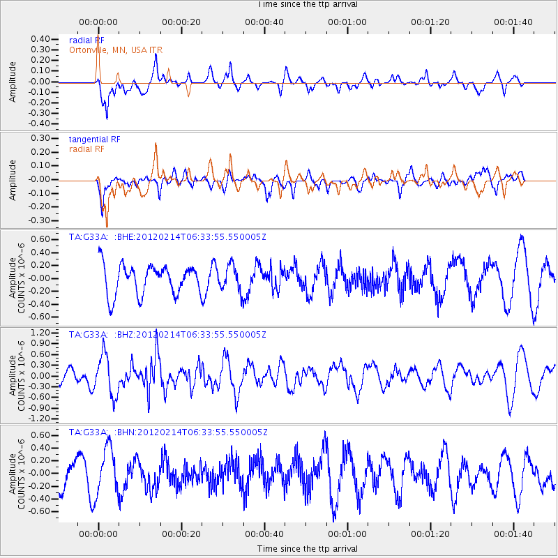
G33A Ortonville, MN, USA - Earthquake Result Viewer
*The percent match for this event was below the threshold and hence no stack was calculated.
| Earthquake location: |
Near East Coast Of Honshu, Japan |
| Earthquake latitude/longitude: |
36.2/141.4 |
| Earthquake time(UTC): |
2012/02/14 (045) 06:22:01 GMT |
| Earthquake Depth: |
28 km |
| Earthquake Magnitude: |
5.6 MB, 5.6 MS, 5.8 MW, 5.7 MW |
| Earthquake Catalog/Contributor: |
WHDF/NEIC |
|
| Network: |
TA USArray Transportable Network (new EarthScope stations) |
| Station: |
G33A Ortonville, MN, USA |
| Lat/Lon: |
45.19 N/96.44 W |
| Elevation: |
338 m |
|
| Distance: |
83.6 deg |
| Az: |
37.03 deg |
| Baz: |
316.465 deg |
| Ray Param: |
$rayparam |
*The percent match for this event was below the threshold and hence was not used in the summary stack. |
|
| Radial Match: |
59.006336 % |
| Radial Bump: |
400 |
| Transverse Match: |
65.09048 % |
| Transverse Bump: |
400 |
| SOD ConfigId: |
439822 |
| Insert Time: |
2012-04-27 09:09:12.616 +0000 |
| GWidth: |
2.5 |
| Max Bumps: |
400 |
| Tol: |
0.001 |
|
Signal To Noise
| Channel | StoN | STA | LTA |
| TA:G33A: :BHZ:20120214T06:33:55.550005Z | 2.8964803 | 5.8071856E-7 | 2.0049113E-7 |
| TA:G33A: :BHN:20120214T06:33:55.550005Z | 2.0796328 | 3.663618E-7 | 1.7616658E-7 |
| TA:G33A: :BHE:20120214T06:33:55.550005Z | 0.86763525 | 2.0050265E-7 | 2.3109095E-7 |
| Arrivals |
| Ps | |
| PpPs | |
| PsPs/PpSs | |


