You are here: Home > Network List > TA - USArray Transportable Network (new EarthScope stations) Stations List
> Station W41B Gary Mavity, Velonia, AR, USA > Earthquake Result Viewer
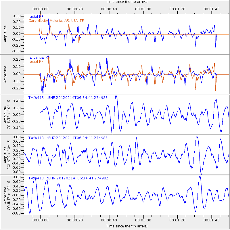
W41B Gary Mavity, Velonia, AR, USA - Earthquake Result Viewer
*The percent match for this event was below the threshold and hence no stack was calculated.
| Earthquake location: |
Near East Coast Of Honshu, Japan |
| Earthquake latitude/longitude: |
36.2/141.4 |
| Earthquake time(UTC): |
2012/02/14 (045) 06:22:01 GMT |
| Earthquake Depth: |
28 km |
| Earthquake Magnitude: |
5.6 MB, 5.6 MS, 5.8 MW, 5.7 MW |
| Earthquake Catalog/Contributor: |
WHDF/NEIC |
|
| Network: |
TA USArray Transportable Network (new EarthScope stations) |
| Station: |
W41B Gary Mavity, Velonia, AR, USA |
| Lat/Lon: |
35.17 N/92.25 W |
| Elevation: |
95 m |
|
| Distance: |
93.2 deg |
| Az: |
41.353 deg |
| Baz: |
319.292 deg |
| Ray Param: |
$rayparam |
*The percent match for this event was below the threshold and hence was not used in the summary stack. |
|
| Radial Match: |
50.933952 % |
| Radial Bump: |
400 |
| Transverse Match: |
56.319824 % |
| Transverse Bump: |
343 |
| SOD ConfigId: |
439822 |
| Insert Time: |
2012-04-27 09:10:26.451 +0000 |
| GWidth: |
2.5 |
| Max Bumps: |
400 |
| Tol: |
0.001 |
|
Signal To Noise
| Channel | StoN | STA | LTA |
| TA:W41B: :BHZ:20120214T06:34:41.27498Z | 0.852711 | 2.6824821E-7 | 3.1458276E-7 |
| TA:W41B: :BHN:20120214T06:34:41.27498Z | 2.0203514 | 5.124529E-7 | 2.5364545E-7 |
| TA:W41B: :BHE:20120214T06:34:41.27498Z | 0.37728637 | 8.32998E-8 | 2.2078667E-7 |
| Arrivals |
| Ps | |
| PpPs | |
| PsPs/PpSs | |


