You are here: Home > Network List > AU - Australian Seismological Centre Stations List
> Station BLDU Ballidu, Western Australia > Earthquake Result Viewer
BLDU Ballidu, Western Australia - Earthquake Result Viewer
| Earthquake location: |
Solomon Islands |
| Earthquake latitude/longitude: |
-10.4/161.1 |
| Earthquake time(UTC): |
2012/02/14 (045) 08:19:55 GMT |
| Earthquake Depth: |
51 km |
| Earthquake Magnitude: |
6.2 MB, 6.4 MW, 6.4 MW |
| Earthquake Catalog/Contributor: |
WHDF/NEIC |
|
| Network: |
AU Australian Seismological Centre |
| Station: |
BLDU Ballidu, Western Australia |
| Lat/Lon: |
30.61 S/116.71 E |
| Elevation: |
280 m |
|
| Distance: |
45.8 deg |
| Az: |
237.235 deg |
| Baz: |
73.662 deg |
| Ray Param: |
0.07089201 |
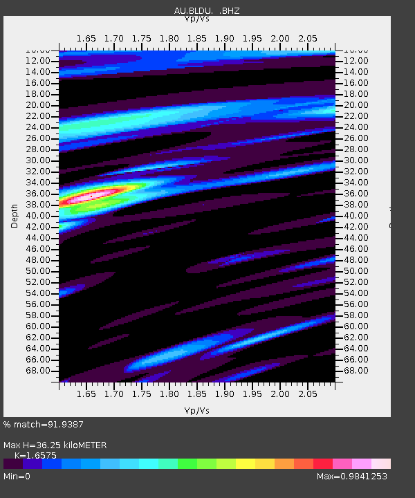
| Estimated Moho Depth: |
36.25 km |
| Estimated Crust Vp/Vs: |
1.66 |
| Assumed Crust Vp: |
6.419 km/s |
| Estimated Crust Vs: |
3.873 km/s |
| Estimated Crust Poisson's Ratio: |
0.21 |
|
| Radial Match: |
91.9387 % |
| Radial Bump: |
386 |
| Transverse Match: |
71.92049 % |
| Transverse Bump: |
395 |
| SOD ConfigId: |
439822 |
| Insert Time: |
2012-04-27 09:19:23.139 +0000 |
| GWidth: |
2.5 |
| Max Bumps: |
400 |
| Tol: |
0.001 |
|

Signal To Noise
| Channel | StoN | STA | LTA |
| AU:BLDU: :BHZ:20120214T08:27:41.894988Z | 4.3493075 | 1.6356369E-6 | 3.7606836E-7 |
| AU:BLDU: :BHN:20120214T08:27:41.894988Z | 4.2034817 | 5.9471853E-7 | 1.4148237E-7 |
| AU:BLDU: :BHE:20120214T08:27:41.894988Z | 5.6323876 | 8.958655E-7 | 1.5905609E-7 |
| Arrivals |
| Ps | 4.0 SECOND |
| PpPs | 14 SECOND |
| PsPs/PpSs | 18 SECOND |


