You are here: Home > Network List > TA - USArray Transportable Network (new EarthScope stations) Stations List
> Station O02D Mt. Diablo Meridian, CA, USA > Earthquake Result Viewer
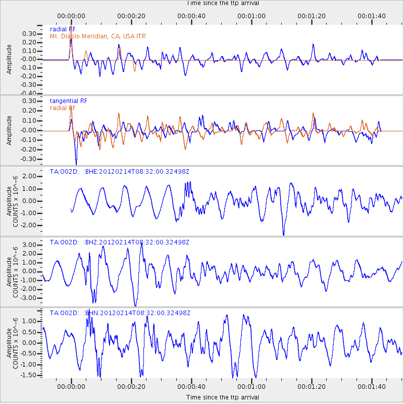
O02D Mt. Diablo Meridian, CA, USA - Earthquake Result Viewer
*The percent match for this event was below the threshold and hence no stack was calculated.
| Earthquake location: |
Solomon Islands |
| Earthquake latitude/longitude: |
-10.4/161.1 |
| Earthquake time(UTC): |
2012/02/14 (045) 08:19:55 GMT |
| Earthquake Depth: |
51 km |
| Earthquake Magnitude: |
6.2 MB, 6.4 MW, 6.4 MW |
| Earthquake Catalog/Contributor: |
WHDF/NEIC |
|
| Network: |
TA USArray Transportable Network (new EarthScope stations) |
| Station: |
O02D Mt. Diablo Meridian, CA, USA |
| Lat/Lon: |
40.18 N/122.79 W |
| Elevation: |
965 m |
|
| Distance: |
86.2 deg |
| Az: |
48.194 deg |
| Baz: |
253.161 deg |
| Ray Param: |
$rayparam |
*The percent match for this event was below the threshold and hence was not used in the summary stack. |
|
| Radial Match: |
74.10904 % |
| Radial Bump: |
400 |
| Transverse Match: |
64.30453 % |
| Transverse Bump: |
400 |
| SOD ConfigId: |
439822 |
| Insert Time: |
2012-04-27 09:25:24.722 +0000 |
| GWidth: |
2.5 |
| Max Bumps: |
400 |
| Tol: |
0.001 |
|
Signal To Noise
| Channel | StoN | STA | LTA |
| TA:O02D: :BHZ:20120214T08:32:00.32498Z | 1.8144388 | 1.2018347E-6 | 6.6237266E-7 |
| TA:O02D: :BHN:20120214T08:32:00.32498Z | 1.0688488 | 6.010268E-7 | 5.623122E-7 |
| TA:O02D: :BHE:20120214T08:32:00.32498Z | 1.2771534 | 8.902413E-7 | 6.9705123E-7 |
| Arrivals |
| Ps | |
| PpPs | |
| PsPs/PpSs | |


