You are here: Home > Network List > TA - USArray Transportable Network (new EarthScope stations) Stations List
> Station 349A Repton, AL, USA > Earthquake Result Viewer
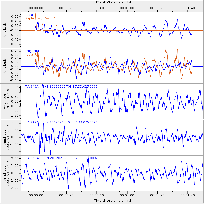
349A Repton, AL, USA - Earthquake Result Viewer
*The percent match for this event was below the threshold and hence no stack was calculated.
| Earthquake location: |
Off Coast Of Oregon |
| Earthquake latitude/longitude: |
43.6/-127.5 |
| Earthquake time(UTC): |
2012/02/15 (046) 03:31:20 GMT |
| Earthquake Depth: |
11 km |
| Earthquake Magnitude: |
5.5 MB, 5.5 MS, 5.8 MW, 5.8 MW |
| Earthquake Catalog/Contributor: |
WHDF/NEIC |
|
| Network: |
TA USArray Transportable Network (new EarthScope stations) |
| Station: |
349A Repton, AL, USA |
| Lat/Lon: |
31.35 N/87.19 W |
| Elevation: |
88 m |
|
| Distance: |
33.9 deg |
| Az: |
97.457 deg |
| Baz: |
302.689 deg |
| Ray Param: |
$rayparam |
*The percent match for this event was below the threshold and hence was not used in the summary stack. |
|
| Radial Match: |
48.821583 % |
| Radial Bump: |
337 |
| Transverse Match: |
65.15436 % |
| Transverse Bump: |
341 |
| SOD ConfigId: |
439822 |
| Insert Time: |
2012-04-27 09:45:49.544 +0000 |
| GWidth: |
2.5 |
| Max Bumps: |
400 |
| Tol: |
0.001 |
|
Signal To Noise
| Channel | StoN | STA | LTA |
| TA:349A: :BHZ:20120215T03:37:33.025009Z | 3.1296809 | 1.149555E-6 | 3.6730742E-7 |
| TA:349A: :BHN:20120215T03:37:33.025009Z | 0.5843791 | 4.437079E-7 | 7.5928097E-7 |
| TA:349A: :BHE:20120215T03:37:33.025009Z | 0.9082993 | 7.4436423E-7 | 8.1951424E-7 |
| Arrivals |
| Ps | |
| PpPs | |
| PsPs/PpSs | |


