You are here: Home > Network List > G - GEOSCOPE Stations List
> Station INU Inuyama, Japan > Earthquake Result Viewer
INU Inuyama, Japan - Earthquake Result Viewer

| Earthquake location: |
Kyrgyzstan |
| Earthquake latitude/longitude: |
42.1/73.6 |
| Earthquake time(UTC): |
1992/08/19 (232) 02:04:36 GMT |
| Earthquake Depth: |
22 km |
| Earthquake Magnitude: |
6.8 MB, 7.4 MS |
| Earthquake Catalog/Contributor: |
WHDF/NEIC |
|
| Network: |
G GEOSCOPE |
| Station: |
INU Inuyama, Japan |
| Lat/Lon: |
35.35 N/137.03 E |
| Elevation: |
132 m |
|
| Distance: |
49.0 deg |
| Az: |
75.808 deg |
| Baz: |
298.014 deg |
| Ray Param: |
0.068971194 |
| Estimated Moho Depth: |
27.5 km |
| Estimated Crust Vp/Vs: |
1.70 |
| Assumed Crust Vp: |
6.461 km/s |
| Estimated Crust Vs: |
3.795 km/s |
| Estimated Crust Poisson's Ratio: |
0.24 |
|
| Radial Match: |
94.26708 % |
| Radial Bump: |
400 |
| Transverse Match: |
87.005775 % |
| Transverse Bump: |
400 |
| SOD ConfigId: |
16938 |
| Insert Time: |
2010-02-26 23:11:51.498 +0000 |
| GWidth: |
2.5 |
| Max Bumps: |
400 |
| Tol: |
0.001 |
|
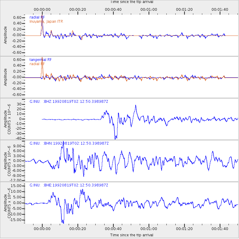
Signal To Noise
| Channel | StoN | STA | LTA |
| G:INU: :BHN:19920819T02:12:50.398987Z | 2.061188 | 1.0201187E-6 | 4.9491786E-7 |
| G:INU: :BHE:19920819T02:12:50.398987Z | 2.75087 | 1.2859075E-6 | 4.674548E-7 |
| G:INU: :BHZ:19920819T02:12:50.398987Z | 7.1660614 | 3.2045723E-6 | 4.4718738E-7 |
| Arrivals |
| Ps | 3.2 SECOND |
| PpPs | 11 SECOND |
| PsPs/PpSs | 14 SECOND |


