You are here: Home > Network List > CI - Caltech Regional Seismic Network Stations List
> Station FMP Fort MacArthur Park, Pt. Fermin San Pedro, CA, USA > Earthquake Result Viewer
FMP Fort MacArthur Park, Pt. Fermin San Pedro, CA, USA - Earthquake Result Viewer
*The percent match for this event was below the threshold and hence no stack was calculated.
| Earthquake location: |
Eastern New Guinea Reg., P.N.G. |
| Earthquake latitude/longitude: |
-7.5/147.0 |
| Earthquake time(UTC): |
2012/02/15 (046) 14:07:51 GMT |
| Earthquake Depth: |
8.0 km |
| Earthquake Magnitude: |
5.8 MB, 5.1 MS, 5.2 MW, 5.3 MW |
| Earthquake Catalog/Contributor: |
WHDF/NEIC |
|
| Network: |
CI Caltech Regional Seismic Network |
| Station: |
FMP Fort MacArthur Park, Pt. Fermin San Pedro, CA, USA |
| Lat/Lon: |
33.71 N/118.29 W |
| Elevation: |
89 m |
|
| Distance: |
98.1 deg |
| Az: |
57.03 deg |
| Baz: |
266.366 deg |
| Ray Param: |
$rayparam |
*The percent match for this event was below the threshold and hence was not used in the summary stack. |
|
| Radial Match: |
83.447014 % |
| Radial Bump: |
400 |
| Transverse Match: |
87.9034 % |
| Transverse Bump: |
400 |
| SOD ConfigId: |
439822 |
| Insert Time: |
2012-04-27 09:52:02.162 +0000 |
| GWidth: |
2.5 |
| Max Bumps: |
400 |
| Tol: |
0.001 |
|
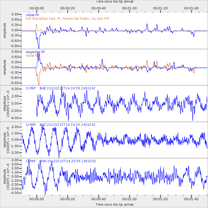
Signal To Noise
| Channel | StoN | STA | LTA |
| CI:FMP: :BHZ:20120215T14:20:56.245024Z | 1.4941936 | 1.5213836E-6 | 1.0181972E-6 |
| CI:FMP: :BHN:20120215T14:20:56.245024Z | 1.2944573 | 1.8756801E-6 | 1.4490088E-6 |
| CI:FMP: :BHE:20120215T14:20:56.245024Z | 0.8335877 | 1.4938558E-6 | 1.79208E-6 |
| Arrivals |
| Ps | |
| PpPs | |
| PsPs/PpSs | |


