You are here: Home > Network List > G - GEOSCOPE Stations List
> Station INU Inuyama, Japan > Earthquake Result Viewer
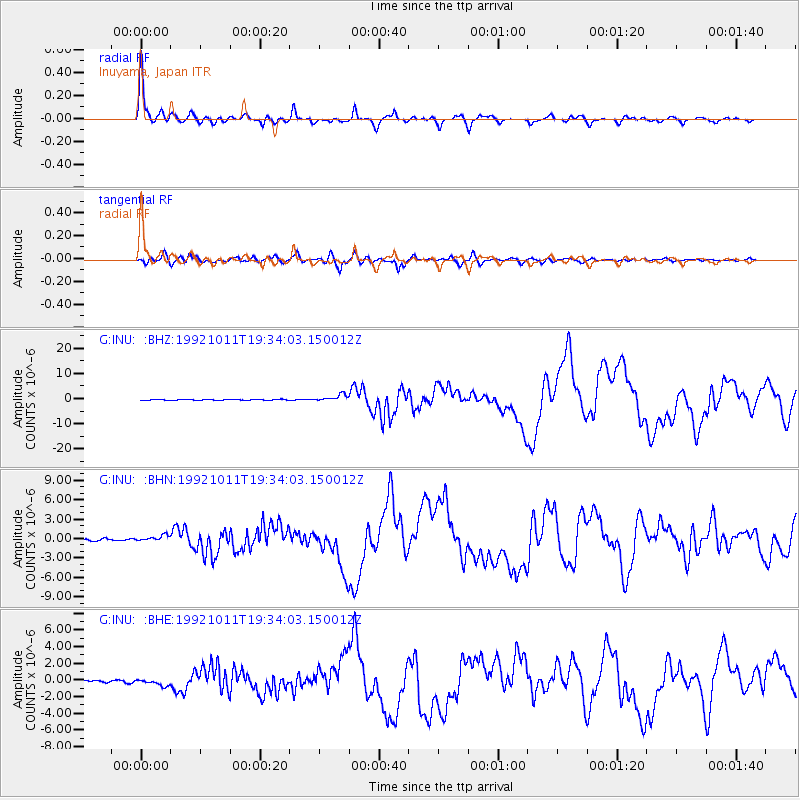
INU Inuyama, Japan - Earthquake Result Viewer

| Earthquake location: |
Vanuatu Islands |
| Earthquake latitude/longitude: |
-19.3/168.9 |
| Earthquake time(UTC): |
1992/10/11 (285) 19:24:29 GMT |
| Earthquake Depth: |
157 km |
| Earthquake Magnitude: |
6.4 MB |
| Earthquake Catalog/Contributor: |
WHDF/NEIC |
|
| Network: |
G GEOSCOPE |
| Station: |
INU Inuyama, Japan |
| Lat/Lon: |
35.35 N/137.03 E |
| Elevation: |
132 m |
|
| Distance: |
62.2 deg |
| Az: |
330.777 deg |
| Baz: |
145.656 deg |
| Ray Param: |
0.05992575 |
| Estimated Moho Depth: |
60.5 km |
| Estimated Crust Vp/Vs: |
1.87 |
| Assumed Crust Vp: |
6.461 km/s |
| Estimated Crust Vs: |
3.455 km/s |
| Estimated Crust Poisson's Ratio: |
0.30 |
|
| Radial Match: |
97.1149 % |
| Radial Bump: |
393 |
| Transverse Match: |
93.763306 % |
| Transverse Bump: |
400 |
| SOD ConfigId: |
16938 |
| Insert Time: |
2010-02-26 23:11:56.249 +0000 |
| GWidth: |
2.5 |
| Max Bumps: |
400 |
| Tol: |
0.001 |
|
Signal To Noise
| Channel | StoN | STA | LTA |
| G:INU: :BHN:19921011T19:34:03.150012Z | 4.087151 | 4.8431934E-7 | 1.1849803E-7 |
| G:INU: :BHE:19921011T19:34:03.150012Z | 3.5516355 | 3.86693E-7 | 1.08877444E-7 |
| G:INU: :BHZ:19921011T19:34:03.150012Z | 8.761197 | 1.3795172E-6 | 1.574576E-7 |
| Arrivals |
| Ps | 8.5 SECOND |
| PpPs | 26 SECOND |
| PsPs/PpSs | 34 SECOND |


