You are here: Home > Network List > G - GEOSCOPE Stations List
> Station INU Inuyama, Japan > Earthquake Result Viewer
INU Inuyama, Japan - Earthquake Result Viewer
| Earthquake location: |
Flores Region, Indonesia |
| Earthquake latitude/longitude: |
-8.5/121.9 |
| Earthquake time(UTC): |
1992/12/12 (347) 05:29:27 GMT |
| Earthquake Depth: |
35 km |
| Earthquake Magnitude: |
6.7 MB, 7.5 MS, 7.5 UNKNOWN |
| Earthquake Catalog/Contributor: |
WHDF/NEIC |
|
| Network: |
G GEOSCOPE |
| Station: |
INU Inuyama, Japan |
| Lat/Lon: |
35.35 N/137.03 E |
| Elevation: |
132 m |
|
| Distance: |
45.9 deg |
| Az: |
17.291 deg |
| Baz: |
201.079 deg |
| Ray Param: |
0.07090392 |
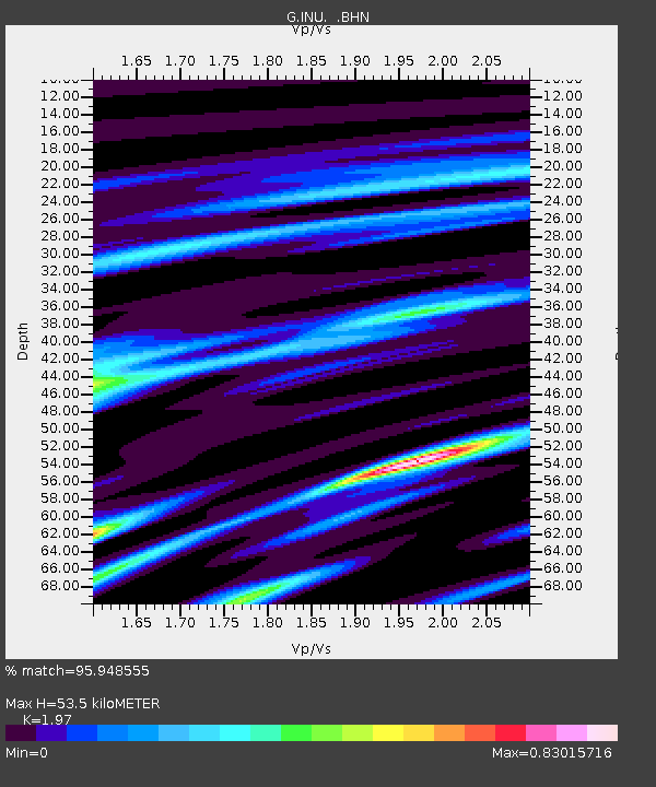
| Estimated Moho Depth: |
53.5 km |
| Estimated Crust Vp/Vs: |
1.97 |
| Assumed Crust Vp: |
6.461 km/s |
| Estimated Crust Vs: |
3.28 km/s |
| Estimated Crust Poisson's Ratio: |
0.33 |
|
| Radial Match: |
95.948555 % |
| Radial Bump: |
352 |
| Transverse Match: |
87.63022 % |
| Transverse Bump: |
400 |
| SOD ConfigId: |
16938 |
| Insert Time: |
2010-02-26 23:12:05.096 +0000 |
| GWidth: |
2.5 |
| Max Bumps: |
400 |
| Tol: |
0.001 |
|

Signal To Noise
| Channel | StoN | STA | LTA |
| G:INU: :BHN:19921212T05:37:16.100012Z | 2.6617246 | 5.026358E-6 | 1.888384E-6 |
| G:INU: :BHE:19921212T05:37:16.100012Z | 1.2510501 | 1.8264069E-6 | 1.4598991E-6 |
| G:INU: :BHZ:19921212T05:37:16.100012Z | 2.9370973 | 6.3978255E-6 | 2.1782819E-6 |
| Arrivals |
| Ps | 8.5 SECOND |
| PpPs | 23 SECOND |
| PsPs/PpSs | 32 SECOND |


