You are here: Home > Network List > CI - Caltech Regional Seismic Network Stations List
> Station BFS Mt Baldy Forest Station > Earthquake Result Viewer
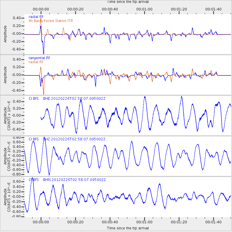
BFS Mt Baldy Forest Station - Earthquake Result Viewer
*The percent match for this event was below the threshold and hence no stack was calculated.
| Earthquake location: |
South Of Fiji Islands |
| Earthquake latitude/longitude: |
-24.5/-177.5 |
| Earthquake time(UTC): |
2012/02/26 (057) 02:46:21 GMT |
| Earthquake Depth: |
10 km |
| Earthquake Magnitude: |
5.5 MW, 5.1 MB |
| Earthquake Catalog/Contributor: |
WHDF/NEIC |
|
| Network: |
CI Caltech Regional Seismic Network |
| Station: |
BFS Mt Baldy Forest Station |
| Lat/Lon: |
34.24 N/117.66 W |
| Elevation: |
1312 m |
|
| Distance: |
81.5 deg |
| Az: |
46.414 deg |
| Baz: |
232.813 deg |
| Ray Param: |
$rayparam |
*The percent match for this event was below the threshold and hence was not used in the summary stack. |
|
| Radial Match: |
74.7519 % |
| Radial Bump: |
400 |
| Transverse Match: |
53.37074 % |
| Transverse Bump: |
400 |
| SOD ConfigId: |
440406 |
| Insert Time: |
2012-05-15 04:21:28.832 +0000 |
| GWidth: |
2.5 |
| Max Bumps: |
400 |
| Tol: |
0.001 |
|
Signal To Noise
| Channel | StoN | STA | LTA |
| CI:BFS: :BHZ:20120226T02:58:07.095002Z | 1.9095728 | 5.5783323E-7 | 2.921246E-7 |
| CI:BFS: :BHN:20120226T02:58:07.095002Z | 0.69154066 | 1.9036771E-7 | 2.7528057E-7 |
| CI:BFS: :BHE:20120226T02:58:07.095002Z | 0.6593603 | 1.4830475E-7 | 2.2492216E-7 |
| Arrivals |
| Ps | |
| PpPs | |
| PsPs/PpSs | |


