You are here: Home > Network List > TA - USArray Transportable Network (new EarthScope stations) Stations List
> Station N02D Trinity Center, CA, USA > Earthquake Result Viewer
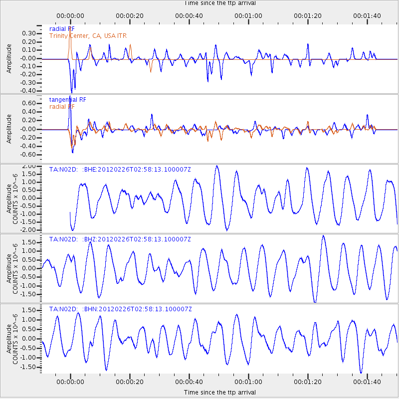
N02D Trinity Center, CA, USA - Earthquake Result Viewer
*The percent match for this event was below the threshold and hence no stack was calculated.
| Earthquake location: |
South Of Fiji Islands |
| Earthquake latitude/longitude: |
-24.5/-177.5 |
| Earthquake time(UTC): |
2012/02/26 (057) 02:46:21 GMT |
| Earthquake Depth: |
10 km |
| Earthquake Magnitude: |
5.5 MW, 5.1 MB |
| Earthquake Catalog/Contributor: |
WHDF/NEIC |
|
| Network: |
TA USArray Transportable Network (new EarthScope stations) |
| Station: |
N02D Trinity Center, CA, USA |
| Lat/Lon: |
40.97 N/122.71 W |
| Elevation: |
937 m |
|
| Distance: |
82.6 deg |
| Az: |
38.599 deg |
| Baz: |
228.655 deg |
| Ray Param: |
$rayparam |
*The percent match for this event was below the threshold and hence was not used in the summary stack. |
|
| Radial Match: |
63.232056 % |
| Radial Bump: |
400 |
| Transverse Match: |
82.43556 % |
| Transverse Bump: |
400 |
| SOD ConfigId: |
440406 |
| Insert Time: |
2012-05-15 04:24:15.129 +0000 |
| GWidth: |
2.5 |
| Max Bumps: |
400 |
| Tol: |
0.001 |
|
Signal To Noise
| Channel | StoN | STA | LTA |
| TA:N02D: :BHZ:20120226T02:58:13.100007Z | 1.2579618 | 8.3422344E-7 | 6.631548E-7 |
| TA:N02D: :BHN:20120226T02:58:13.100007Z | 2.0071268 | 8.980061E-7 | 4.4740875E-7 |
| TA:N02D: :BHE:20120226T02:58:13.100007Z | 0.6481915 | 4.81339E-7 | 7.4258764E-7 |
| Arrivals |
| Ps | |
| PpPs | |
| PsPs/PpSs | |


