You are here: Home > Network List > IW - Intermountain West Stations List
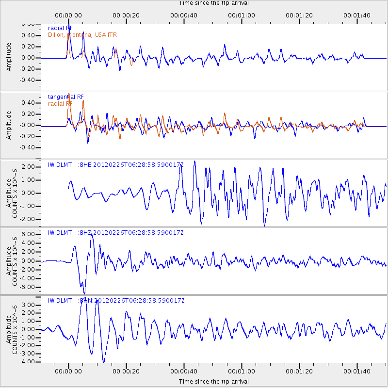
> Station DLMT Dillon, Montana, USA > Earthquake Result Viewer
DLMT Dillon, Montana, USA - Earthquake Result Viewer
| Earthquake location: |
Southwestern Siberia, Russia |
| Earthquake latitude/longitude: |
51.7/96.0 |
| Earthquake time(UTC): |
2012/02/26 (057) 06:17:19 GMT |
| Earthquake Depth: |
12 km |
| Earthquake Magnitude: |
6.4 MB, 6.6 MS, 6.7 MW, 6.5 MW |
| Earthquake Catalog/Contributor: |
WHDF/NEIC |
|
| Network: |
IW Intermountain West |
| Station: |
DLMT Dillon, Montana, USA |
| Lat/Lon: |
45.36 N/112.60 W |
| Elevation: |
1569 m |
|
| Distance: |
80.2 deg |
| Az: |
20.019 deg |
| Baz: |
342.414 deg |
| Ray Param: |
0.04842682 |
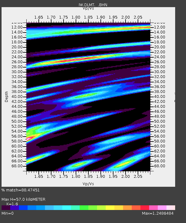
| Estimated Moho Depth: |
57.0 km |
| Estimated Crust Vp/Vs: |
1.60 |
| Assumed Crust Vp: |
6.577 km/s |
| Estimated Crust Vs: |
4.111 km/s |
| Estimated Crust Poisson's Ratio: |
0.18 |
|
| Radial Match: |
88.47451 % |
| Radial Bump: |
347 |
| Transverse Match: |
82.55501 % |
| Transverse Bump: |
400 |
| SOD ConfigId: |
440406 |
| Insert Time: |
2012-05-15 04:51:24.974 +0000 |
| GWidth: |
2.5 |
| Max Bumps: |
400 |
| Tol: |
0.001 |
|
Signal To Noise
| Channel | StoN | STA | LTA |
| IW:DLMT: :BHZ:20120226T06:28:58.590017Z | 9.988608 | 2.6718587E-6 | 2.6749058E-7 |
| IW:DLMT: :BHN:20120226T06:28:58.590017Z | 4.342498 | 1.5795828E-6 | 3.6374982E-7 |
| IW:DLMT: :BHE:20120226T06:28:58.590017Z | 1.2044377 | 3.747156E-7 | 3.1111247E-7 |
| Arrivals |
| Ps | 5.4 SECOND |
| PpPs | 22 SECOND |
| PsPs/PpSs | 27 SECOND |


