You are here: Home > Network List > G - GEOSCOPE Stations List
> Station INU Inuyama, Japan > Earthquake Result Viewer
INU Inuyama, Japan - Earthquake Result Viewer
| Earthquake location: |
Solomon Islands |
| Earthquake latitude/longitude: |
-9.6/158.1 |
| Earthquake time(UTC): |
1993/11/26 (330) 23:20:05 GMT |
| Earthquake Depth: |
23 km |
| Earthquake Magnitude: |
5.8 MB, 6.2 MS, 6.1 UNKNOWN, 6.3 MW |
| Earthquake Catalog/Contributor: |
WHDF/NEIC |
|
| Network: |
G GEOSCOPE |
| Station: |
INU Inuyama, Japan |
| Lat/Lon: |
35.35 N/137.03 E |
| Elevation: |
132 m |
|
| Distance: |
48.9 deg |
| Az: |
337.017 deg |
| Baz: |
151.897 deg |
| Ray Param: |
0.06898523 |
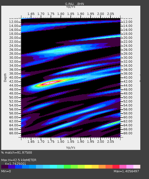
| Estimated Moho Depth: |
42.5 km |
| Estimated Crust Vp/Vs: |
1.74 |
| Assumed Crust Vp: |
6.461 km/s |
| Estimated Crust Vs: |
3.708 km/s |
| Estimated Crust Poisson's Ratio: |
0.25 |
|
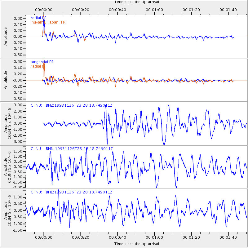
| Radial Match: |
91.97588 % |
| Radial Bump: |
391 |
| Transverse Match: |
71.84182 % |
| Transverse Bump: |
400 |
| SOD ConfigId: |
16938 |
| Insert Time: |
2010-02-26 23:13:04.412 +0000 |
| GWidth: |
2.5 |
| Max Bumps: |
400 |
| Tol: |
0.001 |
|
Signal To Noise
| Channel | StoN | STA | LTA |
| G:INU: :BHN:19931126T23:28:18.749011Z | 2.8070338 | 6.894383E-7 | 2.4561098E-7 |
| G:INU: :BHE:19931126T23:28:18.749011Z | 1.4865694 | 3.40796E-7 | 2.2924996E-7 |
| G:INU: :BHZ:19931126T23:28:18.749011Z | 6.474466 | 1.3847083E-6 | 2.1387221E-7 |
| Arrivals |
| Ps | 5.2 SECOND |
| PpPs | 17 SECOND |
| PsPs/PpSs | 22 SECOND |


