You are here: Home > Network List > TA - USArray Transportable Network (new EarthScope stations) Stations List
> Station T35A Sooner Cattle Company, Foraker, OK, USA > Earthquake Result Viewer
T35A Sooner Cattle Company, Foraker, OK, USA - Earthquake Result Viewer
| Earthquake location: |
Southwestern Siberia, Russia |
| Earthquake latitude/longitude: |
51.7/96.0 |
| Earthquake time(UTC): |
2012/02/26 (057) 06:17:19 GMT |
| Earthquake Depth: |
12 km |
| Earthquake Magnitude: |
6.4 MB, 6.6 MS, 6.7 MW, 6.5 MW |
| Earthquake Catalog/Contributor: |
WHDF/NEIC |
|
| Network: |
TA USArray Transportable Network (new EarthScope stations) |
| Station: |
T35A Sooner Cattle Company, Foraker, OK, USA |
| Lat/Lon: |
36.92 N/96.51 W |
| Elevation: |
401 m |
|
| Distance: |
91.1 deg |
| Az: |
9.994 deg |
| Baz: |
352.257 deg |
| Ray Param: |
0.041627973 |
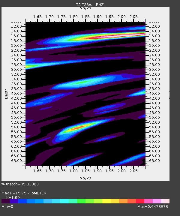
| Estimated Moho Depth: |
15.75 km |
| Estimated Crust Vp/Vs: |
1.99 |
| Assumed Crust Vp: |
6.483 km/s |
| Estimated Crust Vs: |
3.258 km/s |
| Estimated Crust Poisson's Ratio: |
0.33 |
|
| Radial Match: |
85.03363 % |
| Radial Bump: |
373 |
| Transverse Match: |
70.0444 % |
| Transverse Bump: |
400 |
| SOD ConfigId: |
440406 |
| Insert Time: |
2012-05-15 05:03:23.586 +0000 |
| GWidth: |
2.5 |
| Max Bumps: |
400 |
| Tol: |
0.001 |
|
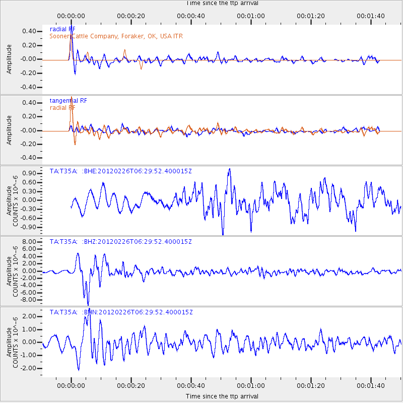
Signal To Noise
| Channel | StoN | STA | LTA |
| TA:T35A: :BHZ:20120226T06:29:52.400015Z | 11.966165 | 3.0774509E-6 | 2.5717938E-7 |
| TA:T35A: :BHN:20120226T06:29:52.400015Z | 3.053364 | 1.0465097E-6 | 3.427399E-7 |
| TA:T35A: :BHE:20120226T06:29:52.400015Z | 0.5129477 | 1.29372E-7 | 2.5221283E-7 |
| Arrivals |
| Ps | 2.5 SECOND |
| PpPs | 7.1 SECOND |
| PsPs/PpSs | 9.6 SECOND |


