You are here: Home > Network List > G - GEOSCOPE Stations List
> Station INU Inuyama, Japan > Earthquake Result Viewer
INU Inuyama, Japan - Earthquake Result Viewer
| Earthquake location: |
Halmahera, Indonesia |
| Earthquake latitude/longitude: |
1.0/127.7 |
| Earthquake time(UTC): |
1994/01/21 (021) 02:24:31 GMT |
| Earthquake Depth: |
33 km |
| Earthquake Magnitude: |
7.2 MS, 7.0 UNKNOWN |
| Earthquake Catalog/Contributor: |
WHDF/NEIC |
|
| Network: |
G GEOSCOPE |
| Station: |
INU Inuyama, Japan |
| Lat/Lon: |
35.35 N/137.03 E |
| Elevation: |
132 m |
|
| Distance: |
35.2 deg |
| Az: |
13.231 deg |
| Baz: |
196.257 deg |
| Ray Param: |
0.07726602 |
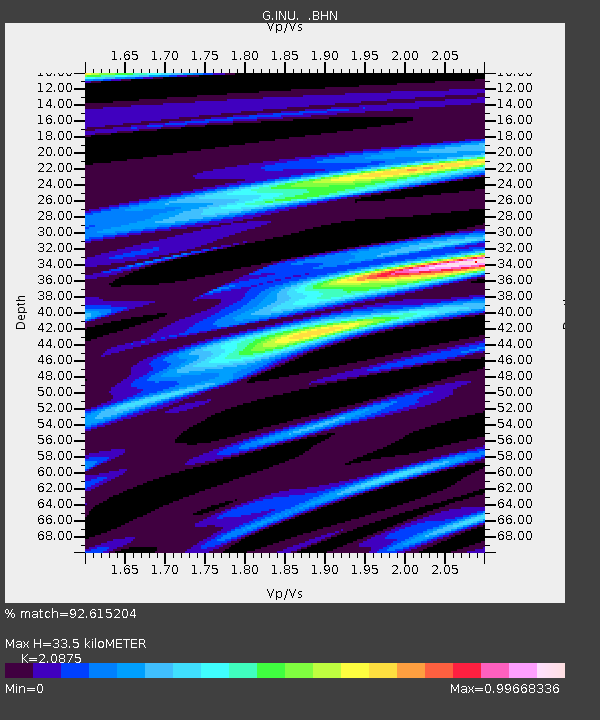
| Estimated Moho Depth: |
33.5 km |
| Estimated Crust Vp/Vs: |
2.09 |
| Assumed Crust Vp: |
6.461 km/s |
| Estimated Crust Vs: |
3.095 km/s |
| Estimated Crust Poisson's Ratio: |
0.35 |
|
| Radial Match: |
92.615204 % |
| Radial Bump: |
284 |
| Transverse Match: |
74.15748 % |
| Transverse Bump: |
400 |
| SOD ConfigId: |
16938 |
| Insert Time: |
2010-02-26 23:13:19.279 +0000 |
| GWidth: |
2.5 |
| Max Bumps: |
400 |
| Tol: |
0.001 |
|
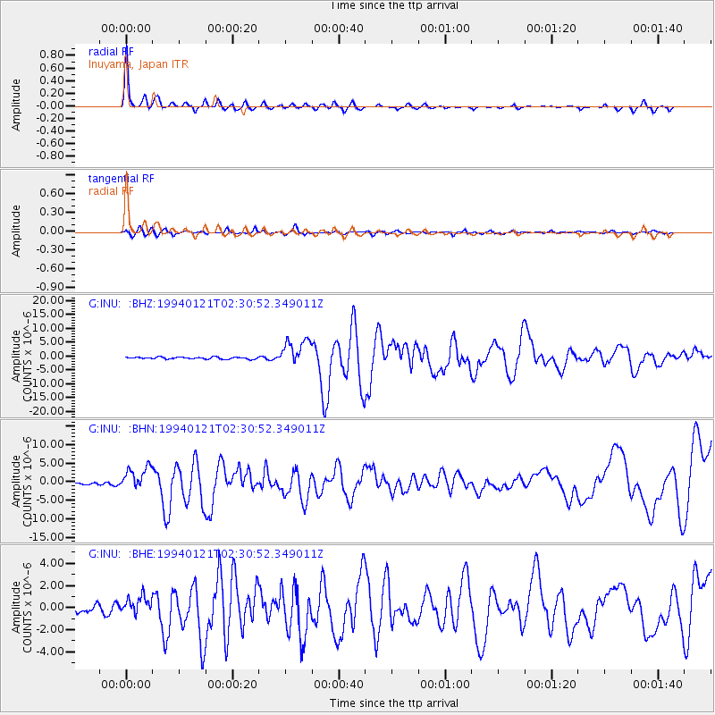
Signal To Noise
| Channel | StoN | STA | LTA |
| G:INU: :BHN:19940121T02:30:52.349011Z | 11.849259 | 3.2663986E-6 | 2.7566267E-7 |
| G:INU: :BHE:19940121T02:30:52.349011Z | 2.8706315 | 8.4182466E-7 | 2.9325415E-7 |
| G:INU: :BHZ:19940121T02:30:52.349011Z | 14.476506 | 4.887649E-6 | 3.376263E-7 |
| Arrivals |
| Ps | 6.0 SECOND |
| PpPs | 15 SECOND |
| PsPs/PpSs | 21 SECOND |


