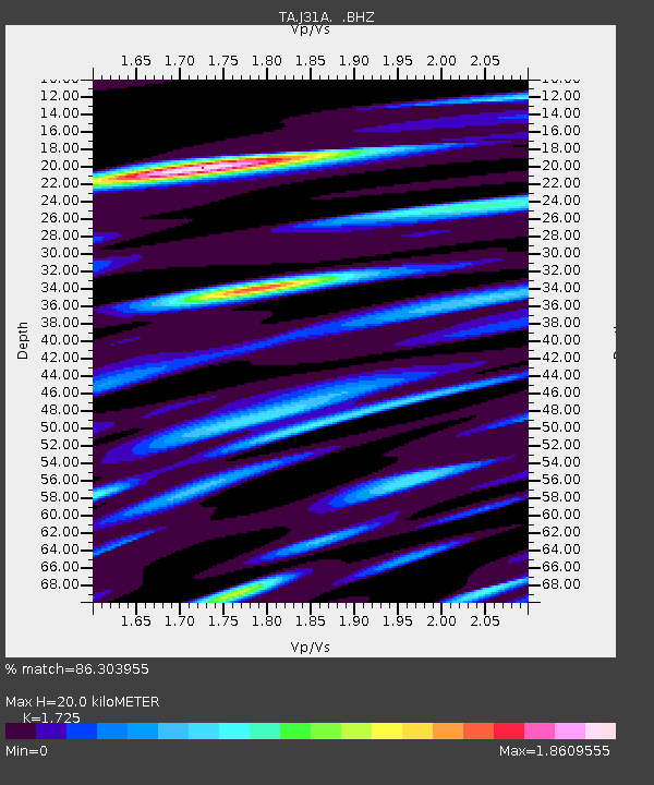
J31A Geddes, SD, USA - Earthquake Result Viewer

Earthquake location: Southwestern Siberia, Russia
Earthquake latitude/longitude: 51.7/96.0
Earthquake time(UTC): 2012/02/26 (057) 06:17:19 GMT
Earthquake Depth: 12 km
Earthquake Magnitude: 6.4 MB, 6.6 MS, 6.7 MW, 6.5 MW
Earthquake Catalog/Contributor: WHDF/NEIC
Network: TA USArray Transportable Network (new EarthScope stations)
Station: J31A Geddes, SD, USA
Lat/Lon: 43.29 N/98.74 W
Elevation: 491 m
Distance: 84.5 deg
Az: 10.749 deg
Baz: 350.854 deg
Ray Param: 0.04542002
Estimated Moho Depth: 20.0 km
Estimated Crust Vp/Vs: 1.73
Assumed Crust Vp: 6.53 km/s
Estimated Crust Vs: 3.786 km/s
Estimated Crust Poisson's Ratio: 0.25
Radial Match: 86.303955 %
Radial Bump: 400
Transverse Match: 80.630325 %
Transverse Bump: 400
SOD ConfigId: 440406
Insert Time: 2012-05-15 05:07:14.629 +0000
GWidth: 2.5
Max Bumps: 400
Tol: 0.001

Signal To Noise

ChannelStoNSTALTA
TA:J31A: :BHZ:20120226T06:29:20.99999Z8.6240025.0670606E-65.875532E-7
TA:J31A: :BHN:20120226T06:29:20.99999Z3.86285921.8634853E-64.824109E-7
TA:J31A: :BHE:20120226T06:29:20.99999Z1.68704956.7946326E-74.0275242E-7
Arrivals
Ps2.3 SECOND
PpPs8.1 SECOND
PsPs/PpSs10 SECOND