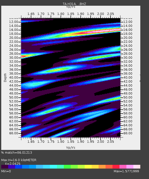
H31A Wolsey, SD, USA - Earthquake Result Viewer
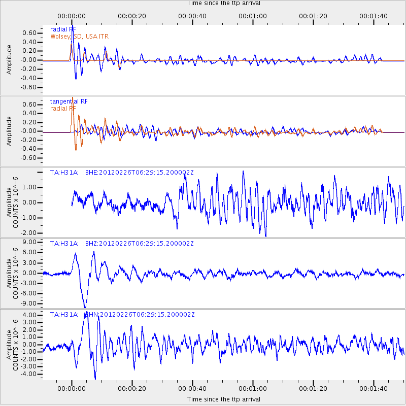
Earthquake location: Southwestern Siberia, Russia
Earthquake latitude/longitude: 51.7/96.0
Earthquake time(UTC): 2012/02/26 (057) 06:17:19 GMT
Earthquake Depth: 12 km
Earthquake Magnitude: 6.4 MB, 6.6 MS, 6.7 MW, 6.5 MW
Earthquake Catalog/Contributor: WHDF/NEIC
Network: TA USArray Transportable Network (new EarthScope stations)
Station: H31A Wolsey, SD, USA
Lat/Lon: 44.48 N/98.48 W
Elevation: 415 m
Distance: 83.4 deg
Az: 10.373 deg
Baz: 350.996 deg
Ray Param: 0.046227552
Estimated Moho Depth: 16.0 km
Estimated Crust Vp/Vs: 2.04
Assumed Crust Vp: 6.53 km/s
Estimated Crust Vs: 3.197 km/s
Estimated Crust Poisson's Ratio: 0.34
Radial Match: 86.01213 %
Radial Bump: 400
Transverse Match: 74.00998 %
Transverse Bump: 400
SOD ConfigId: 440406
Insert Time: 2012-05-15 05:09:06.662 +0000
GWidth: 2.5
Max Bumps: 400
Tol: 0.001

Signal To Noise

ChannelStoNSTALTA
TA:H31A: :BHZ:20120226T06:29:15.200002Z16.5125245.191037E-63.1436971E-7
TA:H31A: :BHN:20120226T06:29:15.200002Z4.9300332.0881862E-64.2356436E-7
TA:H31A: :BHE:20120226T06:29:15.200002Z1.70434285.9698453E-73.502726E-7
Arrivals
Ps2.6 SECOND
PpPs7.3 SECOND
PsPs/PpSs9.9 SECOND