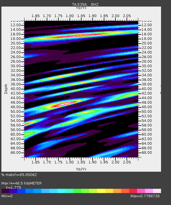
E35A Pequot Lakes, MN, USA - Earthquake Result Viewer

Earthquake location: Southwestern Siberia, Russia
Earthquake latitude/longitude: 51.7/96.0
Earthquake time(UTC): 2012/02/26 (057) 06:17:19 GMT
Earthquake Depth: 12 km
Earthquake Magnitude: 6.4 MB, 6.6 MS, 6.7 MW, 6.5 MW
Earthquake Catalog/Contributor: WHDF/NEIC
Network: TA USArray Transportable Network (new EarthScope stations)
Station: E35A Pequot Lakes, MN, USA
Lat/Lon: 46.56 N/94.40 W
Elevation: 409 m
Distance: 81.7 deg
Az: 7.229 deg
Baz: 353.485 deg
Ray Param: 0.04739436
Estimated Moho Depth: 46.5 km
Estimated Crust Vp/Vs: 1.77
Assumed Crust Vp: 6.419 km/s
Estimated Crust Vs: 3.616 km/s
Estimated Crust Poisson's Ratio: 0.27
Radial Match: 85.85062 %
Radial Bump: 400
Transverse Match: 62.96316 %
Transverse Bump: 400
SOD ConfigId: 440406
Insert Time: 2012-05-15 05:09:46.713 +0000
GWidth: 2.5
Max Bumps: 400
Tol: 0.001

Signal To Noise

ChannelStoNSTALTA
TA:E35A: :BHZ:20120226T06:29:06.525015Z12.99601654.3244036E-63.3274839E-7
TA:E35A: :BHN:20120226T06:29:06.525015Z6.58251762.089686E-63.1746E-7
TA:E35A: :BHE:20120226T06:29:06.525015Z1.77797033.0534144E-71.7173598E-7
Arrivals
Ps5.8 SECOND
PpPs20 SECOND
PsPs/PpSs25 SECOND