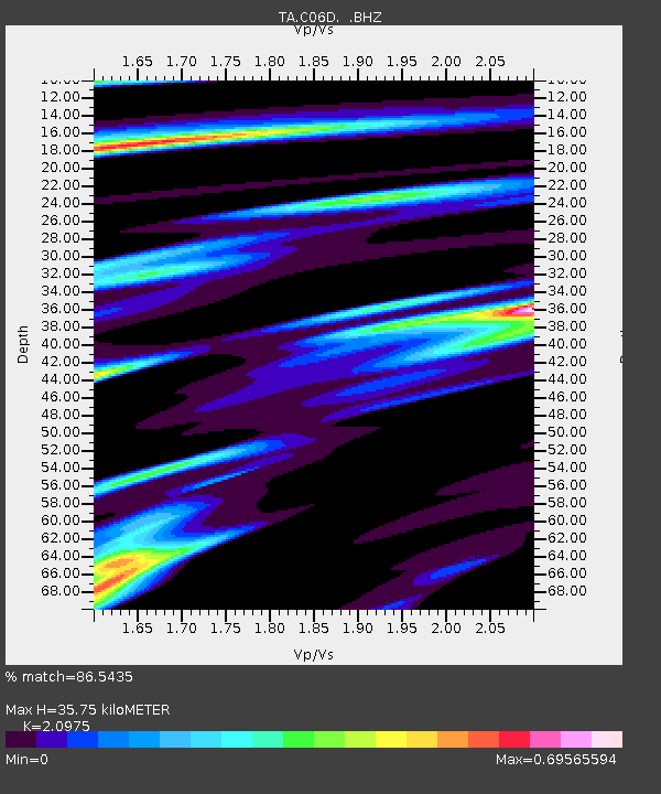
C06D Leavenworth, WQ, USA - Earthquake Result Viewer
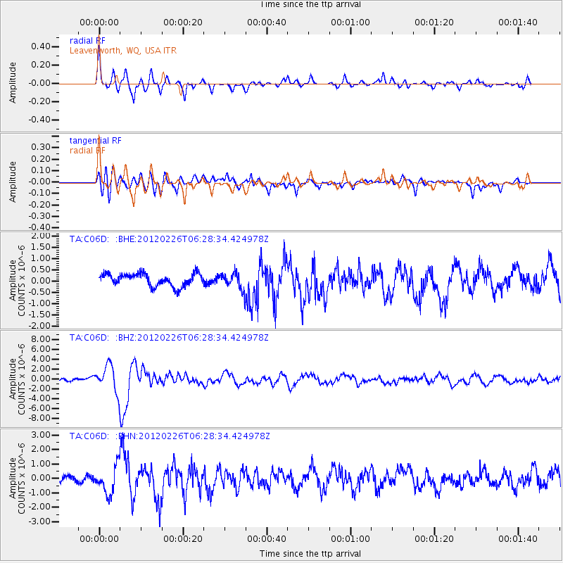
Earthquake location: Southwestern Siberia, Russia
Earthquake latitude/longitude: 51.7/96.0
Earthquake time(UTC): 2012/02/26 (057) 06:17:19 GMT
Earthquake Depth: 12 km
Earthquake Magnitude: 6.4 MB, 6.6 MS, 6.7 MW, 6.5 MW
Earthquake Catalog/Contributor: WHDF/NEIC
Network: TA USArray Transportable Network (new EarthScope stations)
Station: C06D Leavenworth, WQ, USA
Lat/Lon: 47.92 N/120.89 W
Elevation: 544 m
Distance: 75.8 deg
Az: 24.604 deg
Baz: 337.346 deg
Ray Param: 0.051390395
Estimated Moho Depth: 35.75 km
Estimated Crust Vp/Vs: 2.10
Assumed Crust Vp: 6.597 km/s
Estimated Crust Vs: 3.145 km/s
Estimated Crust Poisson's Ratio: 0.35
Radial Match: 86.5435 %
Radial Bump: 400
Transverse Match: 74.39933 %
Transverse Bump: 400
SOD ConfigId: 440406
Insert Time: 2012-05-15 05:11:02.480 +0000
GWidth: 2.5
Max Bumps: 400
Tol: 0.001

Signal To Noise

ChannelStoNSTALTA
TA:C06D: :BHZ:20120226T06:28:34.424978Z6.96333462.747979E-63.946355E-7
TA:C06D: :BHN:20120226T06:28:34.424978Z4.38111169.773736E-72.2308804E-7
TA:C06D: :BHE:20120226T06:28:34.424978Z1.37299763.7963818E-72.7650316E-7
Arrivals
Ps6.1 SECOND
PpPs16 SECOND
PsPs/PpSs22 SECOND