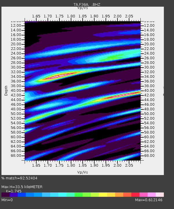
F36A Milaca, MN, USA - Earthquake Result Viewer

Earthquake location: Southwestern Siberia, Russia
Earthquake latitude/longitude: 51.7/96.0
Earthquake time(UTC): 2012/02/26 (057) 06:17:19 GMT
Earthquake Depth: 12 km
Earthquake Magnitude: 6.4 MB, 6.6 MS, 6.7 MW, 6.5 MW
Earthquake Catalog/Contributor: WHDF/NEIC
Network: TA USArray Transportable Network (new EarthScope stations)
Station: F36A Milaca, MN, USA
Lat/Lon: 45.86 N/93.52 W
Elevation: 345 m
Distance: 82.5 deg
Az: 6.691 deg
Baz: 354.045 deg
Ray Param: 0.046865523
Estimated Moho Depth: 33.5 km
Estimated Crust Vp/Vs: 1.75
Assumed Crust Vp: 6.571 km/s
Estimated Crust Vs: 3.765 km/s
Estimated Crust Poisson's Ratio: 0.26
Radial Match: 92.52404 %
Radial Bump: 395
Transverse Match: 82.51309 %
Transverse Bump: 400
SOD ConfigId: 440406
Insert Time: 2012-05-15 05:11:40.245 +0000
GWidth: 2.5
Max Bumps: 400
Tol: 0.001

Signal To Noise

ChannelStoNSTALTA
TA:F36A: :BHZ:20120226T06:29:10.49999Z5.50737674.6964806E-68.527618E-7
TA:F36A: :BHN:20120226T06:29:10.49999Z4.3518591.801805E-64.140311E-7
TA:F36A: :BHE:20120226T06:29:10.49999Z0.952306334.434407E-74.6564926E-7
Arrivals
Ps3.9 SECOND
PpPs14 SECOND
PsPs/PpSs18 SECOND