You are here: Home > Network List > TA - USArray Transportable Network (new EarthScope stations) Stations List
> Station C38A Sawbill Landing (USFS), Superior Nat. Forest, MN, > Earthquake Result Viewer
C38A Sawbill Landing (USFS), Superior Nat. Forest, MN, - Earthquake Result Viewer
| Earthquake location: |
Southwestern Siberia, Russia |
| Earthquake latitude/longitude: |
51.7/96.0 |
| Earthquake time(UTC): |
2012/02/26 (057) 06:17:19 GMT |
| Earthquake Depth: |
12 km |
| Earthquake Magnitude: |
6.4 MB, 6.6 MS, 6.7 MW, 6.5 MW |
| Earthquake Catalog/Contributor: |
WHDF/NEIC |
|
| Network: |
TA USArray Transportable Network (new EarthScope stations) |
| Station: |
C38A Sawbill Landing (USFS), Superior Nat. Forest, MN, |
| Lat/Lon: |
47.72 N/91.27 W |
| Elevation: |
498 m |
|
| Distance: |
80.8 deg |
| Az: |
4.963 deg |
| Baz: |
355.428 deg |
| Ray Param: |
0.048055876 |
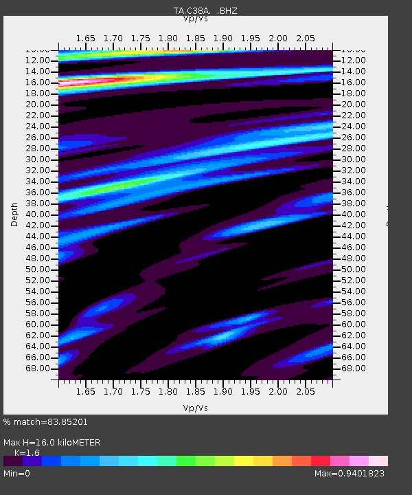
| Estimated Moho Depth: |
16.0 km |
| Estimated Crust Vp/Vs: |
1.60 |
| Assumed Crust Vp: |
6.467 km/s |
| Estimated Crust Vs: |
4.042 km/s |
| Estimated Crust Poisson's Ratio: |
0.18 |
|
| Radial Match: |
83.85201 % |
| Radial Bump: |
400 |
| Transverse Match: |
43.81122 % |
| Transverse Bump: |
400 |
| SOD ConfigId: |
440406 |
| Insert Time: |
2012-05-15 05:12:21.225 +0000 |
| GWidth: |
2.5 |
| Max Bumps: |
400 |
| Tol: |
0.001 |
|
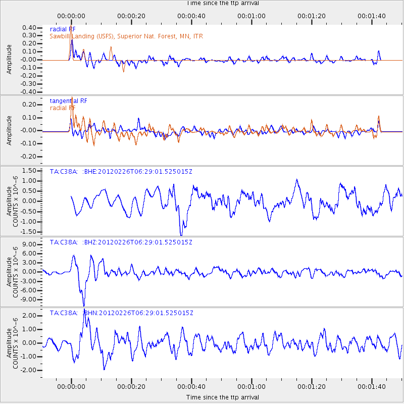
Signal To Noise
| Channel | StoN | STA | LTA |
| TA:C38A: :BHZ:20120226T06:29:01.525015Z | 12.893528 | 5.2285736E-6 | 4.0551922E-7 |
| TA:C38A: :BHN:20120226T06:29:01.525015Z | 4.5561457 | 1.1134688E-6 | 2.443883E-7 |
| TA:C38A: :BHE:20120226T06:29:01.525015Z | 1.2005143 | 4.4702472E-7 | 3.72361E-7 |
| Arrivals |
| Ps | 1.5 SECOND |
| PpPs | 6.2 SECOND |
| PsPs/PpSs | 7.8 SECOND |


