You are here: Home > Network List > G - GEOSCOPE Stations List
> Station INU Inuyama, Japan > Earthquake Result Viewer
INU Inuyama, Japan - Earthquake Result Viewer
| Earthquake location: |
Myanmar |
| Earthquake latitude/longitude: |
20.5/94.2 |
| Earthquake time(UTC): |
1994/05/29 (149) 14:11:51 GMT |
| Earthquake Depth: |
42 km |
| Earthquake Magnitude: |
6.2 MB, 6.2 MS, 5.9 UNKNOWN, 6.5 MW |
| Earthquake Catalog/Contributor: |
WHDF/NEIC |
|
| Network: |
G GEOSCOPE |
| Station: |
INU Inuyama, Japan |
| Lat/Lon: |
35.35 N/137.03 E |
| Elevation: |
132 m |
|
| Distance: |
40.3 deg |
| Az: |
59.254 deg |
| Baz: |
260.174 deg |
| Ray Param: |
0.07436822 |
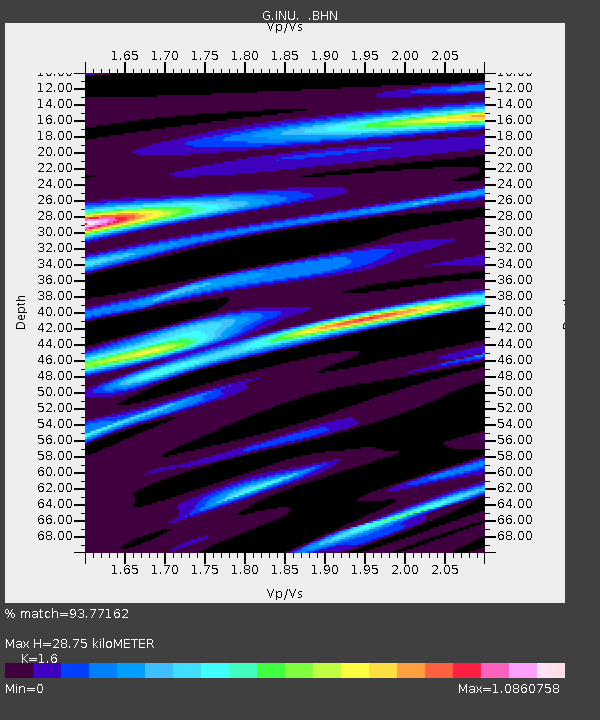
| Estimated Moho Depth: |
28.75 km |
| Estimated Crust Vp/Vs: |
1.60 |
| Assumed Crust Vp: |
6.461 km/s |
| Estimated Crust Vs: |
4.038 km/s |
| Estimated Crust Poisson's Ratio: |
0.18 |
|
| Radial Match: |
93.77162 % |
| Radial Bump: |
296 |
| Transverse Match: |
79.5795 % |
| Transverse Bump: |
400 |
| SOD ConfigId: |
16938 |
| Insert Time: |
2010-02-26 23:13:42.297 +0000 |
| GWidth: |
2.5 |
| Max Bumps: |
400 |
| Tol: |
0.001 |
|

Signal To Noise
| Channel | StoN | STA | LTA |
| G:INU: :BHN:19940529T14:18:54.700Z | 4.3014474 | 4.0694974E-7 | 9.460763E-8 |
| G:INU: :BHE:19940529T14:18:54.700Z | 18.325647 | 1.732387E-6 | 9.453346E-8 |
| G:INU: :BHZ:19940529T14:18:54.700Z | 32.077675 | 3.317923E-6 | 1.0343403E-7 |
| Arrivals |
| Ps | 2.9 SECOND |
| PpPs | 11 SECOND |
| PsPs/PpSs | 14 SECOND |


