You are here: Home > Network List > G - GEOSCOPE Stations List
> Station INU Inuyama, Japan > Earthquake Result Viewer
INU Inuyama, Japan - Earthquake Result Viewer
| Earthquake location: |
South Of Java, Indonesia |
| Earthquake latitude/longitude: |
-10.5/113.0 |
| Earthquake time(UTC): |
1994/06/02 (153) 18:17:36 GMT |
| Earthquake Depth: |
39 km |
| Earthquake Magnitude: |
5.5 MB, 7.2 MS, 6.8 UNKNOWN, 7.7 MW |
| Earthquake Catalog/Contributor: |
WHDF/NEIC |
|
| Network: |
G GEOSCOPE |
| Station: |
INU Inuyama, Japan |
| Lat/Lon: |
35.35 N/137.03 E |
| Elevation: |
132 m |
|
| Distance: |
50.9 deg |
| Az: |
25.411 deg |
| Baz: |
211.085 deg |
| Ray Param: |
0.06764719 |
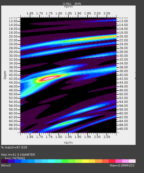
| Estimated Moho Depth: |
41.5 km |
| Estimated Crust Vp/Vs: |
1.75 |
| Assumed Crust Vp: |
6.461 km/s |
| Estimated Crust Vs: |
3.698 km/s |
| Estimated Crust Poisson's Ratio: |
0.26 |
|
| Radial Match: |
97.929 % |
| Radial Bump: |
319 |
| Transverse Match: |
87.63319 % |
| Transverse Bump: |
400 |
| SOD ConfigId: |
16938 |
| Insert Time: |
2010-02-26 23:13:44.291 +0000 |
| GWidth: |
2.5 |
| Max Bumps: |
400 |
| Tol: |
0.001 |
|
Signal To Noise
| Channel | StoN | STA | LTA |
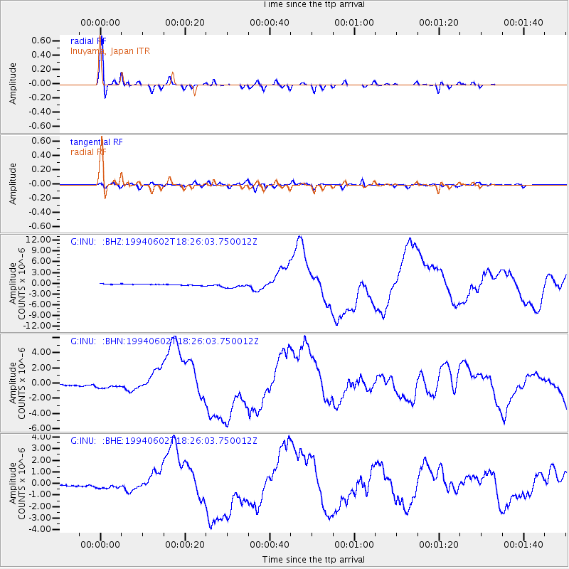
| G:INU: :BHN:19940602T18:26:03.750012Z | 4.43951 | 4.403194E-7 | 9.918198E-8 |
| G:INU: :BHE:19940602T18:26:03.750012Z | 3.5637865 | 2.4906169E-7 | 6.9886816E-8 |
| G:INU: :BHZ:19940602T18:26:03.750012Z | 4.1314554 | 7.439474E-7 | 1.8006908E-7 |
| Arrivals |
| Ps | 5.1 SECOND |
| PpPs | 17 SECOND |
| PsPs/PpSs | 22 SECOND |


