You are here: Home > Network List > TA - USArray Transportable Network (new EarthScope stations) Stations List
> Station N36A Muff Farm, Clarinda, IA, USA > Earthquake Result Viewer
N36A Muff Farm, Clarinda, IA, USA - Earthquake Result Viewer

| Earthquake location: |
Southwestern Siberia, Russia |
| Earthquake latitude/longitude: |
51.7/96.0 |
| Earthquake time(UTC): |
2012/02/26 (057) 06:17:19 GMT |
| Earthquake Depth: |
12 km |
| Earthquake Magnitude: |
6.4 MB, 6.6 MS, 6.7 MW, 6.5 MW |
| Earthquake Catalog/Contributor: |
WHDF/NEIC |
|
| Network: |
TA USArray Transportable Network (new EarthScope stations) |
| Station: |
N36A Muff Farm, Clarinda, IA, USA |
| Lat/Lon: |
40.82 N/94.96 W |
| Elevation: |
349 m |
|
| Distance: |
87.4 deg |
| Az: |
8.299 deg |
| Baz: |
353.204 deg |
| Ray Param: |
0.043375663 |
| Estimated Moho Depth: |
35.25 km |
| Estimated Crust Vp/Vs: |
1.95 |
| Assumed Crust Vp: |
6.498 km/s |
| Estimated Crust Vs: |
3.341 km/s |
| Estimated Crust Poisson's Ratio: |
0.32 |
|
| Radial Match: |
90.47802 % |
| Radial Bump: |
400 |
| Transverse Match: |
77.6052 % |
| Transverse Bump: |
400 |
| SOD ConfigId: |
440406 |
| Insert Time: |
2012-05-15 05:15:40.260 +0000 |
| GWidth: |
2.5 |
| Max Bumps: |
400 |
| Tol: |
0.001 |
|
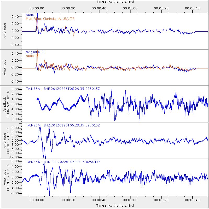
Signal To Noise
| Channel | StoN | STA | LTA |
| TA:N36A: :BHZ:20120226T06:29:35.025015Z | 5.870357 | 5.803987E-6 | 9.886941E-7 |
| TA:N36A: :BHN:20120226T06:29:35.025015Z | 3.5021055 | 2.3808814E-6 | 6.7984286E-7 |
| TA:N36A: :BHE:20120226T06:29:35.025015Z | 2.0446663 | 1.3921151E-6 | 6.80852E-7 |
| Arrivals |
| Ps | 5.2 SECOND |
| PpPs | 16 SECOND |
| PsPs/PpSs | 21 SECOND |


