You are here: Home > Network List > G - GEOSCOPE Stations List
> Station INU Inuyama, Japan > Earthquake Result Viewer
INU Inuyama, Japan - Earthquake Result Viewer
| Earthquake location: |
South Of Java, Indonesia |
| Earthquake latitude/longitude: |
-10.8/113.4 |
| Earthquake time(UTC): |
1994/06/04 (155) 00:57:53 GMT |
| Earthquake Depth: |
33 km |
| Earthquake Magnitude: |
5.8 MB, 6.2 MS, 6.0 UNKNOWN |
| Earthquake Catalog/Contributor: |
WHDF/NEIC |
|
| Network: |
G GEOSCOPE |
| Station: |
INU Inuyama, Japan |
| Lat/Lon: |
35.35 N/137.03 E |
| Elevation: |
132 m |
|
| Distance: |
51.0 deg |
| Az: |
24.906 deg |
| Baz: |
210.412 deg |
| Ray Param: |
0.067613855 |
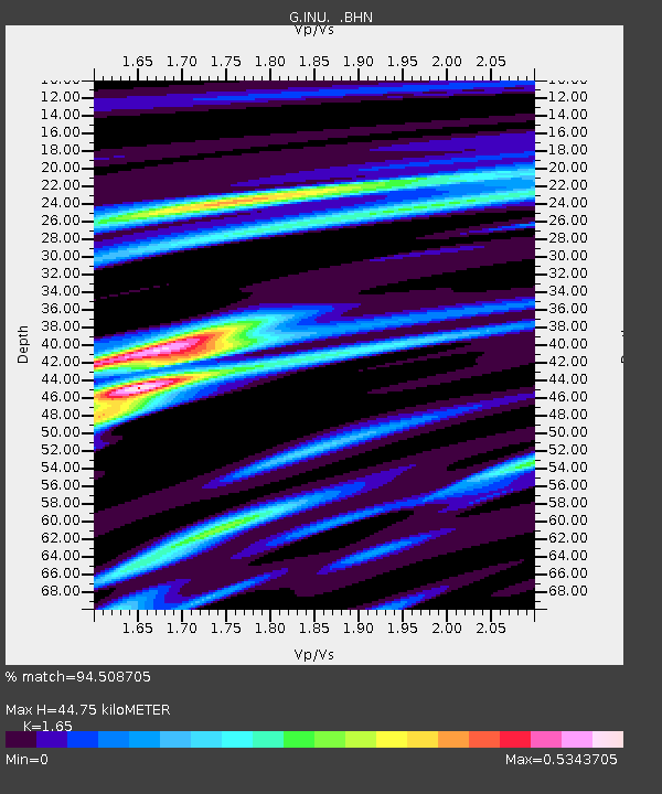
| Estimated Moho Depth: |
44.75 km |
| Estimated Crust Vp/Vs: |
1.65 |
| Assumed Crust Vp: |
6.461 km/s |
| Estimated Crust Vs: |
3.916 km/s |
| Estimated Crust Poisson's Ratio: |
0.21 |
|
| Radial Match: |
94.508705 % |
| Radial Bump: |
398 |
| Transverse Match: |
88.357185 % |
| Transverse Bump: |
400 |
| SOD ConfigId: |
16938 |
| Insert Time: |
2010-02-26 23:13:49.674 +0000 |
| GWidth: |
2.5 |
| Max Bumps: |
400 |
| Tol: |
0.001 |
|

Signal To Noise
| Channel | StoN | STA | LTA |
| G:INU: :BHN:19940604T01:06:21.700012Z | 13.979245 | 9.703632E-7 | 6.941456E-8 |
| G:INU: :BHE:19940604T01:06:21.700012Z | 10.779487 | 6.553504E-7 | 6.079607E-8 |
| G:INU: :BHZ:19940604T01:06:21.700012Z | 40.40046 | 2.4516767E-6 | 6.068438E-8 |
| Arrivals |
| Ps | 4.8 SECOND |
| PpPs | 17 SECOND |
| PsPs/PpSs | 22 SECOND |


