You are here: Home > Network List > G - GEOSCOPE Stations List
> Station INU Inuyama, Japan > Earthquake Result Viewer
INU Inuyama, Japan - Earthquake Result Viewer
| Earthquake location: |
Vanuatu Islands |
| Earthquake latitude/longitude: |
-16.6/167.5 |
| Earthquake time(UTC): |
1994/07/13 (194) 02:35:55 GMT |
| Earthquake Depth: |
33 km |
| Earthquake Magnitude: |
6.3 MB, 7.4 MS, 7.3 UNKNOWN, 7.1 MW |
| Earthquake Catalog/Contributor: |
WHDF/NEIC |
|
| Network: |
G GEOSCOPE |
| Station: |
INU Inuyama, Japan |
| Lat/Lon: |
35.35 N/137.03 E |
| Elevation: |
132 m |
|
| Distance: |
59.2 deg |
| Az: |
331.145 deg |
| Baz: |
145.529 deg |
| Ray Param: |
0.062270127 |
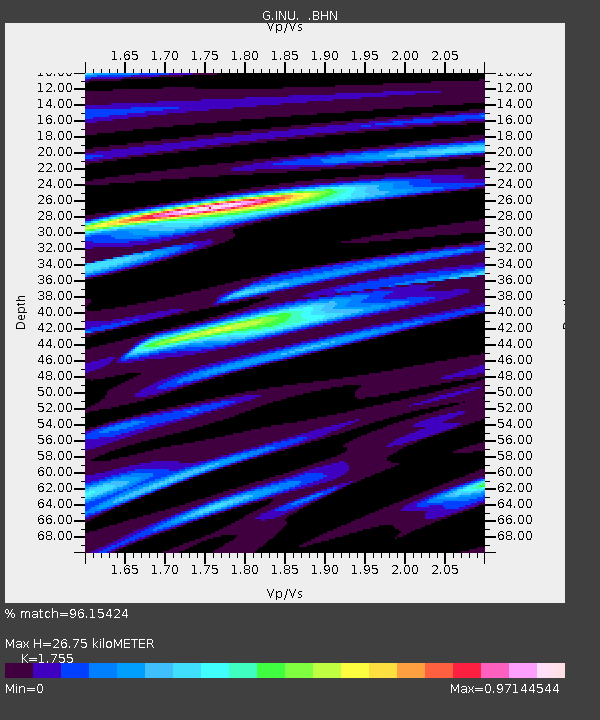
| Estimated Moho Depth: |
26.75 km |
| Estimated Crust Vp/Vs: |
1.75 |
| Assumed Crust Vp: |
6.461 km/s |
| Estimated Crust Vs: |
3.682 km/s |
| Estimated Crust Poisson's Ratio: |
0.26 |
|
| Radial Match: |
96.15424 % |
| Radial Bump: |
361 |
| Transverse Match: |
85.092094 % |
| Transverse Bump: |
400 |
| SOD ConfigId: |
16938 |
| Insert Time: |
2010-02-26 23:13:57.526 +0000 |
| GWidth: |
2.5 |
| Max Bumps: |
400 |
| Tol: |
0.001 |
|

Signal To Noise
| Channel | StoN | STA | LTA |
| G:INU: :BHN:19940713T02:45:23.099011Z | 6.6452274 | 9.049849E-7 | 1.3618569E-7 |
| G:INU: :BHE:19940713T02:45:23.099011Z | 5.8804245 | 6.7242075E-7 | 1.1434901E-7 |
| G:INU: :BHZ:19940713T02:45:23.099011Z | 15.421814 | 2.2269662E-6 | 1.4440364E-7 |
| Arrivals |
| Ps | 3.3 SECOND |
| PpPs | 11 SECOND |
| PsPs/PpSs | 14 SECOND |


