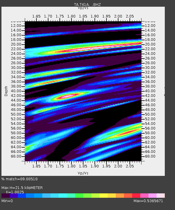
T41A Mountain View, MO, USA - Earthquake Result Viewer
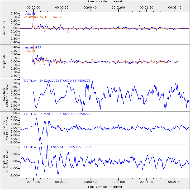
Earthquake location: Southwestern Siberia, Russia
Earthquake latitude/longitude: 51.7/96.0
Earthquake time(UTC): 2012/02/26 (057) 06:17:19 GMT
Earthquake Depth: 12 km
Earthquake Magnitude: 6.4 MB, 6.6 MS, 6.7 MW, 6.5 MW
Earthquake Catalog/Contributor: WHDF/NEIC
Network: TA USArray Transportable Network (new EarthScope stations)
Station: T41A Mountain View, MO, USA
Lat/Lon: 37.04 N/91.76 W
Elevation: 366 m
Distance: 91.4 deg
Az: 6.199 deg
Baz: 355.183 deg
Ray Param: 0.041607317
Estimated Moho Depth: 21.5 km
Estimated Crust Vp/Vs: 1.88
Assumed Crust Vp: 6.53 km/s
Estimated Crust Vs: 3.469 km/s
Estimated Crust Poisson's Ratio: 0.30
Radial Match: 89.88518 %
Radial Bump: 387
Transverse Match: 75.05615 %
Transverse Bump: 400
SOD ConfigId: 440406
Insert Time: 2012-05-15 05:20:53.122 +0000
GWidth: 2.5
Max Bumps: 400
Tol: 0.001

Signal To Noise

ChannelStoNSTALTA
TA:T41A: :BHZ:20120226T06:29:53.725027Z5.90122373.3258755E-65.635908E-7
TA:T41A: :BHN:20120226T06:29:53.725027Z2.85513571.0136633E-63.5503157E-7
TA:T41A: :BHE:20120226T06:29:53.725027Z1.10712715.412154E-74.8884675E-7
Arrivals
Ps3.0 SECOND
PpPs9.3 SECOND
PsPs/PpSs12 SECOND