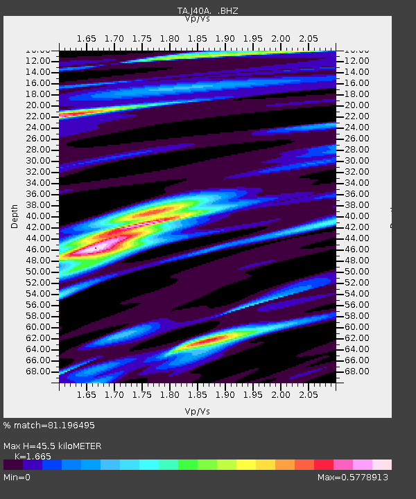
J40A Soldiers Grove, WI, USA - Earthquake Result Viewer

Earthquake location: Southwestern Siberia, Russia
Earthquake latitude/longitude: 51.7/96.0
Earthquake time(UTC): 2012/02/26 (057) 06:17:19 GMT
Earthquake Depth: 12 km
Earthquake Magnitude: 6.4 MB, 6.6 MS, 6.7 MW, 6.5 MW
Earthquake Catalog/Contributor: WHDF/NEIC
Network: TA USArray Transportable Network (new EarthScope stations)
Station: J40A Soldiers Grove, WI, USA
Lat/Lon: 43.40 N/90.74 W
Elevation: 353 m
Distance: 85.1 deg
Az: 4.92 deg
Baz: 355.802 deg
Ray Param: 0.04500722
Estimated Moho Depth: 45.5 km
Estimated Crust Vp/Vs: 1.66
Assumed Crust Vp: 6.53 km/s
Estimated Crust Vs: 3.922 km/s
Estimated Crust Poisson's Ratio: 0.22
Radial Match: 81.196495 %
Radial Bump: 400
Transverse Match: 70.856255 %
Transverse Bump: 400
SOD ConfigId: 440406
Insert Time: 2012-05-15 05:22:55.249 +0000
GWidth: 2.5
Max Bumps: 400
Tol: 0.001

Signal To Noise

ChannelStoNSTALTA
TA:J40A: :BHZ:20120226T06:29:23.900015Z9.913094.782988E-64.8249217E-7
TA:J40A: :BHN:20120226T06:29:23.900015Z6.20149661.3212141E-62.1304761E-7
TA:J40A: :BHE:20120226T06:29:23.900015Z1.31437924.670907E-73.553698E-7
Arrivals
Ps4.8 SECOND
PpPs18 SECOND
PsPs/PpSs23 SECOND