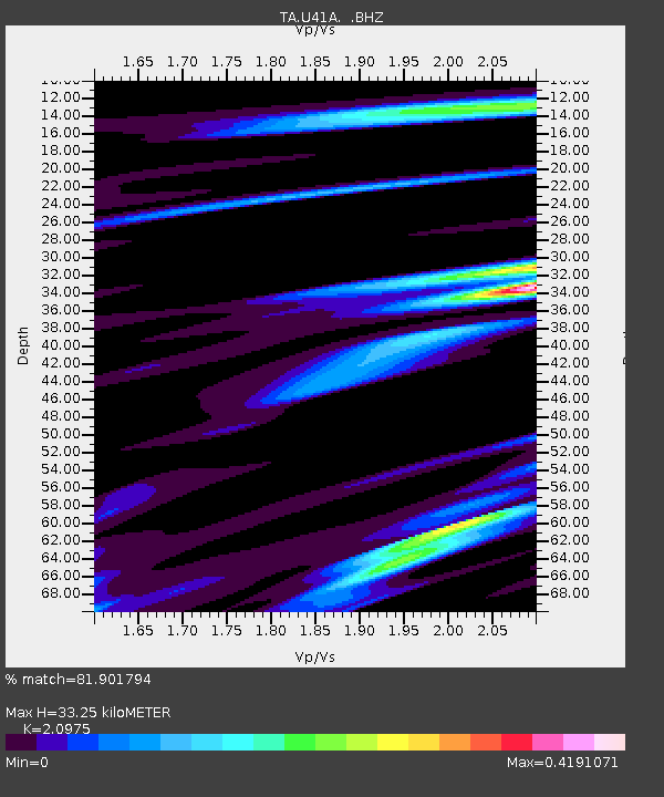
U41A Viola, AR, USA - Earthquake Result Viewer
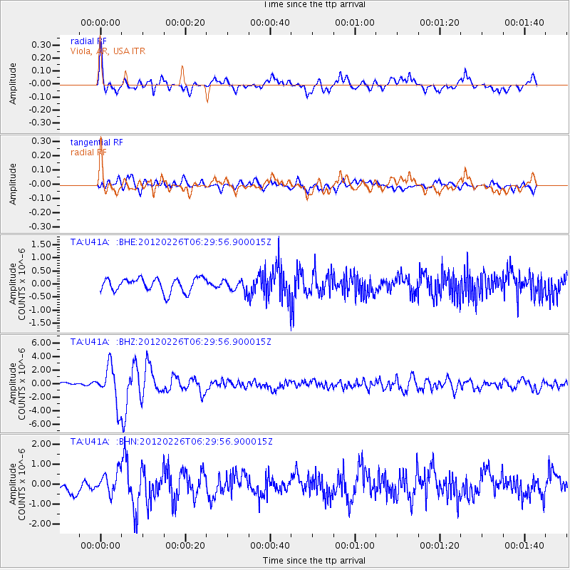
Earthquake location: Southwestern Siberia, Russia
Earthquake latitude/longitude: 51.7/96.0
Earthquake time(UTC): 2012/02/26 (057) 06:17:19 GMT
Earthquake Depth: 12 km
Earthquake Magnitude: 6.4 MB, 6.6 MS, 6.7 MW, 6.5 MW
Earthquake Catalog/Contributor: WHDF/NEIC
Network: TA USArray Transportable Network (new EarthScope stations)
Station: U41A Viola, AR, USA
Lat/Lon: 36.34 N/91.92 W
Elevation: 300 m
Distance: 92.0 deg
Az: 6.384 deg
Baz: 355.084 deg
Ray Param: 0.04151711
Estimated Moho Depth: 33.25 km
Estimated Crust Vp/Vs: 2.10
Assumed Crust Vp: 6.53 km/s
Estimated Crust Vs: 3.113 km/s
Estimated Crust Poisson's Ratio: 0.35
Radial Match: 81.901794 %
Radial Bump: 400
Transverse Match: 71.573204 %
Transverse Bump: 400
SOD ConfigId: 440406
Insert Time: 2012-05-15 05:23:23.353 +0000
GWidth: 2.5
Max Bumps: 400
Tol: 0.001

Signal To Noise

ChannelStoNSTALTA
TA:U41A: :BHZ:20120226T06:29:56.900015Z8.7832052.9440557E-63.3519152E-7
TA:U41A: :BHN:20120226T06:29:56.900015Z1.99617255.553168E-72.7819078E-7
TA:U41A: :BHE:20120226T06:29:56.900015Z0.905437052.3549468E-72.600895E-7
Arrivals
Ps5.7 SECOND
PpPs15 SECOND
PsPs/PpSs21 SECOND