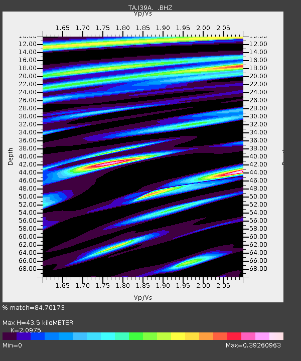
I39A Houston, MN, USA - Earthquake Result Viewer

Earthquake location: Southwestern Siberia, Russia
Earthquake latitude/longitude: 51.7/96.0
Earthquake time(UTC): 2012/02/26 (057) 06:17:19 GMT
Earthquake Depth: 12 km
Earthquake Magnitude: 6.4 MB, 6.6 MS, 6.7 MW, 6.5 MW
Earthquake Catalog/Contributor: WHDF/NEIC
Network: TA USArray Transportable Network (new EarthScope stations)
Station: I39A Houston, MN, USA
Lat/Lon: 43.85 N/91.52 W
Elevation: 393 m
Distance: 84.6 deg
Az: 5.453 deg
Baz: 355.312 deg
Ray Param: 0.04536688
Estimated Moho Depth: 43.5 km
Estimated Crust Vp/Vs: 2.10
Assumed Crust Vp: 6.53 km/s
Estimated Crust Vs: 3.113 km/s
Estimated Crust Poisson's Ratio: 0.35
Radial Match: 84.70173 %
Radial Bump: 400
Transverse Match: 81.79937 %
Transverse Bump: 400
SOD ConfigId: 440406
Insert Time: 2012-05-15 05:25:07.581 +0000
GWidth: 2.5
Max Bumps: 400
Tol: 0.001

Signal To Noise

ChannelStoNSTALTA
TA:I39A: :BHZ:20120226T06:29:21.37499Z14.1819344.6466057E-63.276426E-7
TA:I39A: :BHN:20120226T06:29:21.37499Z4.3176691.525338E-63.5327812E-7
TA:I39A: :BHE:20120226T06:29:21.37499Z1.63051214.7157934E-72.8922162E-7
Arrivals
Ps7.5 SECOND
PpPs20 SECOND
PsPs/PpSs28 SECOND