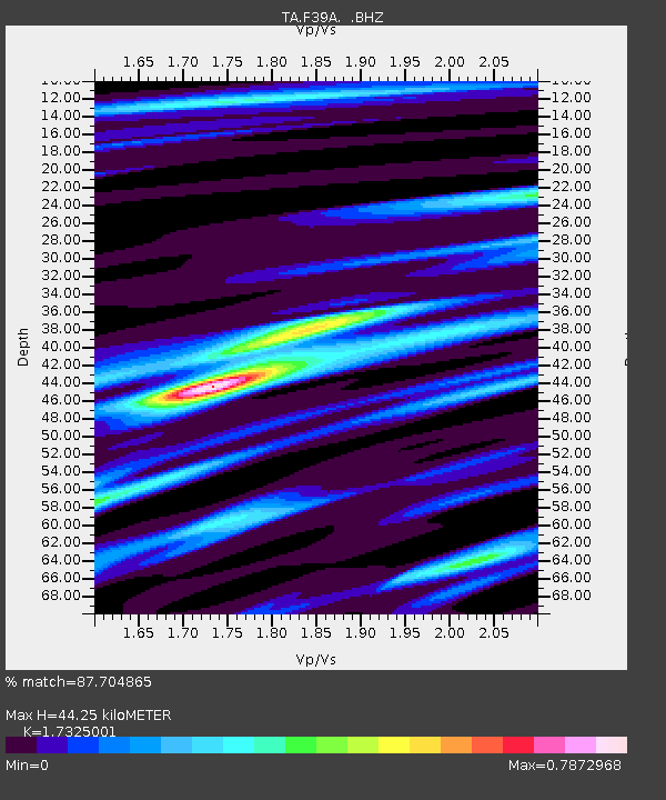
F39A Loretta, WI, USA - Earthquake Result Viewer
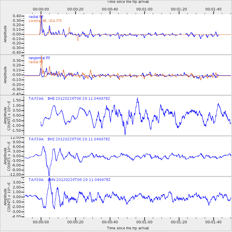
Earthquake location: Southwestern Siberia, Russia
Earthquake latitude/longitude: 51.7/96.0
Earthquake time(UTC): 2012/02/26 (057) 06:17:19 GMT
Earthquake Depth: 12 km
Earthquake Magnitude: 6.4 MB, 6.6 MS, 6.7 MW, 6.5 MW
Earthquake Catalog/Contributor: WHDF/NEIC
Network: TA USArray Transportable Network (new EarthScope stations)
Station: F39A Loretta, WI, USA
Lat/Lon: 45.92 N/90.92 W
Elevation: 440 m
Distance: 82.6 deg
Az: 4.859 deg
Baz: 355.67 deg
Ray Param: 0.046789326
Estimated Moho Depth: 44.25 km
Estimated Crust Vp/Vs: 1.73
Assumed Crust Vp: 6.571 km/s
Estimated Crust Vs: 3.793 km/s
Estimated Crust Poisson's Ratio: 0.25
Radial Match: 87.704865 %
Radial Bump: 400
Transverse Match: 80.68929 %
Transverse Bump: 400
SOD ConfigId: 440406
Insert Time: 2012-05-15 05:27:14.528 +0000
GWidth: 2.5
Max Bumps: 400
Tol: 0.001

Signal To Noise

ChannelStoNSTALTA
TA:F39A: :BHZ:20120226T06:29:11.049978Z7.4125345.5248324E-67.4533654E-7
TA:F39A: :BHN:20120226T06:29:11.049978Z3.60659811.5810762E-64.3838435E-7
TA:F39A: :BHE:20120226T06:29:11.049978Z1.19504646.421896E-75.373763E-7
Arrivals
Ps5.1 SECOND
PpPs18 SECOND
PsPs/PpSs23 SECOND