You are here: Home > Network List > TA - USArray Transportable Network (new EarthScope stations) Stations List
> Station H43A Windswept, Luxemburg, WI, USA > Earthquake Result Viewer
H43A Windswept, Luxemburg, WI, USA - Earthquake Result Viewer
| Earthquake location: |
Southwestern Siberia, Russia |
| Earthquake latitude/longitude: |
51.7/96.0 |
| Earthquake time(UTC): |
2012/02/26 (057) 06:17:19 GMT |
| Earthquake Depth: |
12 km |
| Earthquake Magnitude: |
6.4 MB, 6.6 MS, 6.7 MW, 6.5 MW |
| Earthquake Catalog/Contributor: |
WHDF/NEIC |
|
| Network: |
TA USArray Transportable Network (new EarthScope stations) |
| Station: |
H43A Windswept, Luxemburg, WI, USA |
| Lat/Lon: |
44.47 N/87.77 W |
| Elevation: |
274 m |
|
| Distance: |
84.1 deg |
| Az: |
2.706 deg |
| Baz: |
357.648 deg |
| Ray Param: |
0.045683954 |
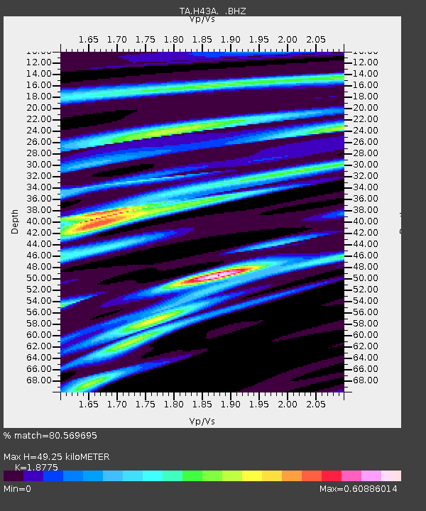
| Estimated Moho Depth: |
49.25 km |
| Estimated Crust Vp/Vs: |
1.88 |
| Assumed Crust Vp: |
6.53 km/s |
| Estimated Crust Vs: |
3.478 km/s |
| Estimated Crust Poisson's Ratio: |
0.30 |
|
| Radial Match: |
80.569695 % |
| Radial Bump: |
400 |
| Transverse Match: |
66.79283 % |
| Transverse Bump: |
396 |
| SOD ConfigId: |
440406 |
| Insert Time: |
2012-05-15 05:28:58.424 +0000 |
| GWidth: |
2.5 |
| Max Bumps: |
400 |
| Tol: |
0.001 |
|

Signal To Noise
| Channel | StoN | STA | LTA |
| TA:H43A: :BHZ:20120226T06:29:19.12499Z | 6.6242294 | 3.9345214E-6 | 5.939591E-7 |
| TA:H43A: :BHN:20120226T06:29:19.12499Z | 4.0376472 | 1.5837519E-6 | 3.922462E-7 |
| TA:H43A: :BHE:20120226T06:29:19.12499Z | 1.0067211 | 6.311017E-7 | 6.268883E-7 |
| Arrivals |
| Ps | 6.8 SECOND |
| PpPs | 21 SECOND |
| PsPs/PpSs | 28 SECOND |


