N44A Piper City, IL, USA - Earthquake Result Viewer
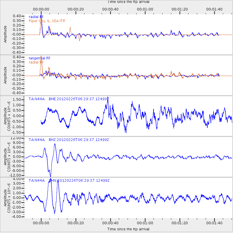
Earthquake location: Southwestern Siberia, Russia
Earthquake latitude/longitude: 51.7/96.0
Earthquake time(UTC): 2012/02/26 (057) 06:17:19 GMT
Earthquake Depth: 12 km
Earthquake Magnitude: 6.4 MB, 6.6 MS, 6.7 MW, 6.5 MW
Earthquake Catalog/Contributor: WHDF/NEIC
Network: TA USArray Transportable Network (new EarthScope stations)
Station: N44A Piper City, IL, USA
Lat/Lon: 40.80 N/88.13 W
Elevation: 202 m
Distance: 87.8 deg
Az: 3.132 deg
Baz: 357.433 deg
Ray Param: 0.04305433
Estimated Moho Depth: 35.75 km
Estimated Crust Vp/Vs: 1.85
Assumed Crust Vp: 6.498 km/s
Estimated Crust Vs: 3.517 km/s
Estimated Crust Poisson's Ratio: 0.29
Radial Match: 89.97615 %
Radial Bump: 382
Transverse Match: 77.471 %
Transverse Bump: 400
SOD ConfigId: 440406
Insert Time: 2012-05-15 05:29:48.461 +0000
GWidth: 2.5
Max Bumps: 400
Tol: 0.001

Signal To Noise

ChannelStoNSTALTA
TA:N44A: :BHZ:20120226T06:29:37.12499Z7.45560844.4130816E-65.919144E-7
TA:N44A: :BHN:20120226T06:29:37.12499Z4.71416141.8187452E-63.8580458E-7
TA:N44A: :BHE:20120226T06:29:37.12499Z1.12875185.807456E-75.145025E-7
Arrivals
Ps4.8 SECOND
PpPs15 SECOND
PsPs/PpSs20 SECOND