You are here: Home > Network List > TA - USArray Transportable Network (new EarthScope stations) Stations List
> Station I43A Langenfeld Brothers Farm, Elkhart Lake, WI, USA > Earthquake Result Viewer
I43A Langenfeld Brothers Farm, Elkhart Lake, WI, USA - Earthquake Result Viewer
| Earthquake location: |
Southwestern Siberia, Russia |
| Earthquake latitude/longitude: |
51.7/96.0 |
| Earthquake time(UTC): |
2012/02/26 (057) 06:17:19 GMT |
| Earthquake Depth: |
12 km |
| Earthquake Magnitude: |
6.4 MB, 6.6 MS, 6.7 MW, 6.5 MW |
| Earthquake Catalog/Contributor: |
WHDF/NEIC |
|
| Network: |
TA USArray Transportable Network (new EarthScope stations) |
| Station: |
I43A Langenfeld Brothers Farm, Elkhart Lake, WI, USA |
| Lat/Lon: |
43.88 N/88.15 W |
| Elevation: |
299 m |
|
| Distance: |
84.7 deg |
| Az: |
3.003 deg |
| Baz: |
357.416 deg |
| Ray Param: |
0.0452771 |
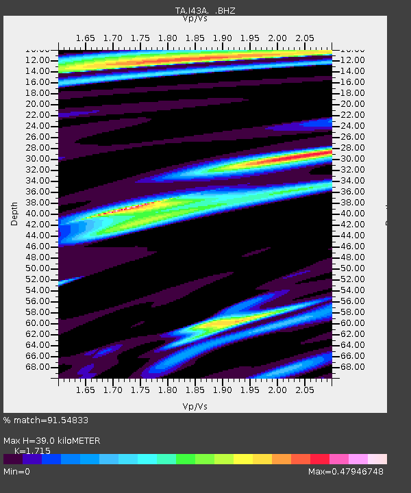
| Estimated Moho Depth: |
39.0 km |
| Estimated Crust Vp/Vs: |
1.72 |
| Assumed Crust Vp: |
6.571 km/s |
| Estimated Crust Vs: |
3.831 km/s |
| Estimated Crust Poisson's Ratio: |
0.24 |
|
| Radial Match: |
91.54833 % |
| Radial Bump: |
400 |
| Transverse Match: |
83.54148 % |
| Transverse Bump: |
400 |
| SOD ConfigId: |
440406 |
| Insert Time: |
2012-05-15 05:30:44.633 +0000 |
| GWidth: |
2.5 |
| Max Bumps: |
400 |
| Tol: |
0.001 |
|
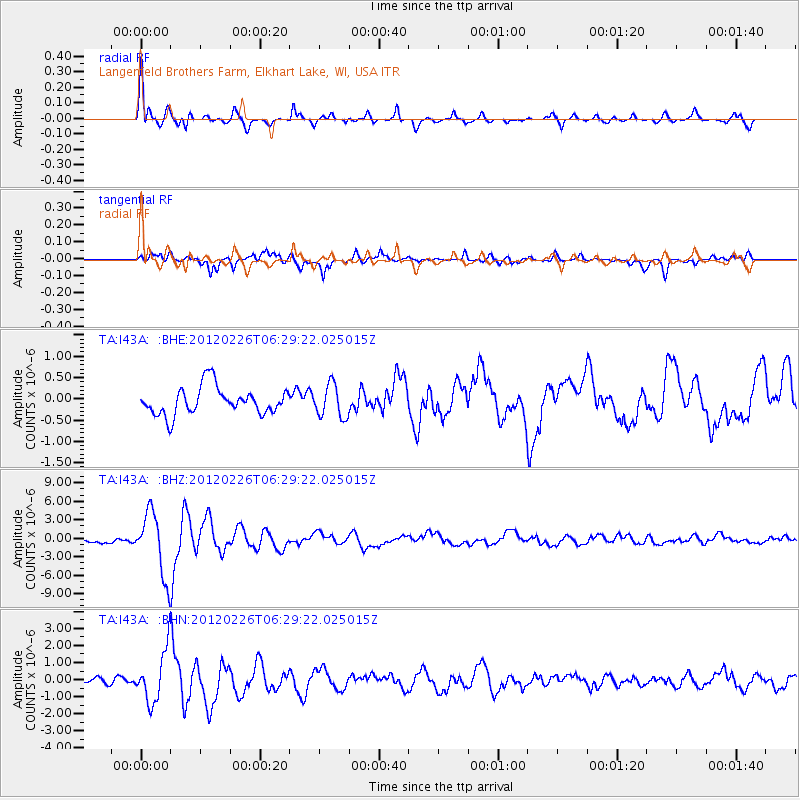
Signal To Noise
| Channel | StoN | STA | LTA |
| TA:I43A: :BHZ:20120226T06:29:22.025015Z | 9.976924 | 5.122528E-6 | 5.1343756E-7 |
| TA:I43A: :BHN:20120226T06:29:22.025015Z | 6.537146 | 1.4857801E-6 | 2.2728268E-7 |
| TA:I43A: :BHE:20120226T06:29:22.025015Z | 1.1956835 | 3.8653394E-7 | 3.2327446E-7 |
| Arrivals |
| Ps | 4.4 SECOND |
| PpPs | 16 SECOND |
| PsPs/PpSs | 20 SECOND |


