You are here: Home > Network List > TA - USArray Transportable Network (new EarthScope stations) Stations List
> Station L42A Oliver, Polo, IL, USA > Earthquake Result Viewer
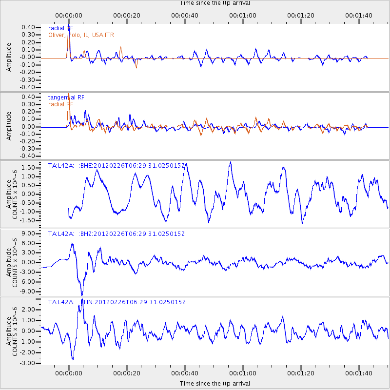
L42A Oliver, Polo, IL, USA - Earthquake Result Viewer

| Earthquake location: |
Southwestern Siberia, Russia |
| Earthquake latitude/longitude: |
51.7/96.0 |
| Earthquake time(UTC): |
2012/02/26 (057) 06:17:19 GMT |
| Earthquake Depth: |
12 km |
| Earthquake Magnitude: |
6.4 MB, 6.6 MS, 6.7 MW, 6.5 MW |
| Earthquake Catalog/Contributor: |
WHDF/NEIC |
|
| Network: |
TA USArray Transportable Network (new EarthScope stations) |
| Station: |
L42A Oliver, Polo, IL, USA |
| Lat/Lon: |
42.00 N/89.67 W |
| Elevation: |
257 m |
|
| Distance: |
86.5 deg |
| Az: |
4.222 deg |
| Baz: |
356.476 deg |
| Ray Param: |
0.043977194 |
| Estimated Moho Depth: |
35.75 km |
| Estimated Crust Vp/Vs: |
2.10 |
| Assumed Crust Vp: |
6.571 km/s |
| Estimated Crust Vs: |
3.133 km/s |
| Estimated Crust Poisson's Ratio: |
0.35 |
|
| Radial Match: |
85.092125 % |
| Radial Bump: |
400 |
| Transverse Match: |
86.27063 % |
| Transverse Bump: |
398 |
| SOD ConfigId: |
440406 |
| Insert Time: |
2012-05-15 05:31:18.447 +0000 |
| GWidth: |
2.5 |
| Max Bumps: |
400 |
| Tol: |
0.001 |
|
Signal To Noise
| Channel | StoN | STA | LTA |
| TA:L42A: :BHZ:20120226T06:29:31.025015Z | 4.5470424 | 5.072997E-6 | 1.1156696E-6 |
| TA:L42A: :BHN:20120226T06:29:31.025015Z | 5.426068 | 1.7403663E-6 | 3.2074172E-7 |
| TA:L42A: :BHE:20120226T06:29:31.025015Z | 1.0794767 | 9.036523E-7 | 8.371207E-7 |
| Arrivals |
| Ps | 6.1 SECOND |
| PpPs | 17 SECOND |
| PsPs/PpSs | 23 SECOND |


