You are here: Home > Network List > G - GEOSCOPE Stations List
> Station INU Inuyama, Japan > Earthquake Result Viewer
INU Inuyama, Japan - Earthquake Result Viewer

| Earthquake location: |
Solomon Islands |
| Earthquake latitude/longitude: |
-8.6/156.6 |
| Earthquake time(UTC): |
1995/04/17 (107) 01:14:20 GMT |
| Earthquake Depth: |
36 km |
| Earthquake Magnitude: |
5.8 MB, 6.0 MS, 5.9 UNKNOWN, 6.1 MW |
| Earthquake Catalog/Contributor: |
WHDF/NEIC |
|
| Network: |
G GEOSCOPE |
| Station: |
INU Inuyama, Japan |
| Lat/Lon: |
35.35 N/137.03 E |
| Elevation: |
132 m |
|
| Distance: |
47.4 deg |
| Az: |
338.165 deg |
| Baz: |
153.259 deg |
| Ray Param: |
0.06990643 |
| Estimated Moho Depth: |
42.75 km |
| Estimated Crust Vp/Vs: |
1.74 |
| Assumed Crust Vp: |
6.461 km/s |
| Estimated Crust Vs: |
3.719 km/s |
| Estimated Crust Poisson's Ratio: |
0.25 |
|
| Radial Match: |
91.90068 % |
| Radial Bump: |
390 |
| Transverse Match: |
80.08919 % |
| Transverse Bump: |
400 |
| SOD ConfigId: |
6273 |
| Insert Time: |
2010-02-26 23:14:44.026 +0000 |
| GWidth: |
2.5 |
| Max Bumps: |
400 |
| Tol: |
0.001 |
|
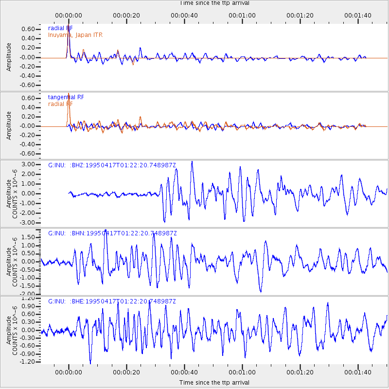
Signal To Noise
| Channel | StoN | STA | LTA |
| G:INU: :BHN:19950417T01:22:20.748987Z | 4.799868 | 5.621866E-7 | 1.17125424E-7 |
| G:INU: :BHE:19950417T01:22:20.748987Z | 2.08453 | 2.0870502E-7 | 1.001209E-7 |
| G:INU: :BHZ:19950417T01:22:20.748987Z | 9.430698 | 1.1664391E-6 | 1.2368534E-7 |
| Arrivals |
| Ps | 5.2 SECOND |
| PpPs | 17 SECOND |
| PsPs/PpSs | 22 SECOND |


