You are here: Home > Network List > US - United States National Seismic Network Stations List
> Station NEW Newport, Washington, USA > Earthquake Result Viewer
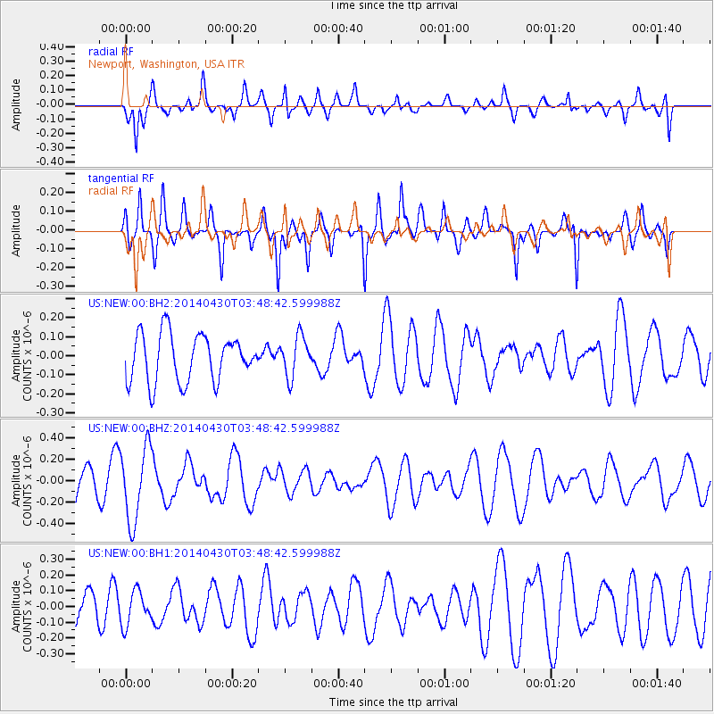
NEW Newport, Washington, USA - Earthquake Result Viewer
*The percent match for this event was below the threshold and hence no stack was calculated.
| Earthquake location: |
Tonga Islands Region |
| Earthquake latitude/longitude: |
-23.5/-175.5 |
| Earthquake time(UTC): |
2014/04/30 (120) 03:36:23 GMT |
| Earthquake Depth: |
20 km |
| Earthquake Magnitude: |
5.3 MW |
| Earthquake Catalog/Contributor: |
ISC/ISC |
|
| Network: |
US United States National Seismic Network |
| Station: |
NEW Newport, Washington, USA |
| Lat/Lon: |
48.26 N/117.12 W |
| Elevation: |
760 m |
|
| Distance: |
88.5 deg |
| Az: |
34.713 deg |
| Baz: |
231.505 deg |
| Ray Param: |
$rayparam |
*The percent match for this event was below the threshold and hence was not used in the summary stack. |
|
| Radial Match: |
60.876144 % |
| Radial Bump: |
400 |
| Transverse Match: |
75.09651 % |
| Transverse Bump: |
400 |
| SOD ConfigId: |
3390531 |
| Insert Time: |
2019-04-11 15:32:12.306 +0000 |
| GWidth: |
2.5 |
| Max Bumps: |
400 |
| Tol: |
0.001 |
|
Signal To Noise
| Channel | StoN | STA | LTA |
| US:NEW:00:BHZ:20140430T03:48:42.599988Z | 2.5891292 | 3.466243E-7 | 1.3387678E-7 |
| US:NEW:00:BH1:20140430T03:48:42.599988Z | 1.4838719 | 1.0825626E-7 | 7.295526E-8 |
| US:NEW:00:BH2:20140430T03:48:42.599988Z | 0.861562 | 1.0699421E-7 | 1.2418631E-7 |
| Arrivals |
| Ps | |
| PpPs | |
| PsPs/PpSs | |


