You are here: Home > Network List > G - GEOSCOPE Stations List
> Station INU Inuyama, Japan > Earthquake Result Viewer
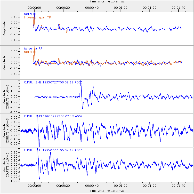
INU Inuyama, Japan - Earthquake Result Viewer

| Earthquake location: |
South Indian Ocean |
| Earthquake latitude/longitude: |
-12.6/79.2 |
| Earthquake time(UTC): |
1995/07/27 (208) 05:51:17 GMT |
| Earthquake Depth: |
10 km |
| Earthquake Magnitude: |
6.2 MB, 5.9 MS, 6.0 UNKNOWN, 6.0 MW |
| Earthquake Catalog/Contributor: |
WHDF/NEIC |
|
| Network: |
G GEOSCOPE |
| Station: |
INU Inuyama, Japan |
| Lat/Lon: |
35.35 N/137.03 E |
| Elevation: |
132 m |
|
| Distance: |
72.5 deg |
| Az: |
46.489 deg |
| Baz: |
240.017 deg |
| Ray Param: |
0.053621054 |
| Estimated Moho Depth: |
28.75 km |
| Estimated Crust Vp/Vs: |
1.62 |
| Assumed Crust Vp: |
6.461 km/s |
| Estimated Crust Vs: |
3.995 km/s |
| Estimated Crust Poisson's Ratio: |
0.19 |
|
| Radial Match: |
94.249214 % |
| Radial Bump: |
382 |
| Transverse Match: |
88.25124 % |
| Transverse Bump: |
400 |
| SOD ConfigId: |
6273 |
| Insert Time: |
2010-02-26 23:15:13.915 +0000 |
| GWidth: |
2.5 |
| Max Bumps: |
400 |
| Tol: |
0.001 |
|
Signal To Noise
| Channel | StoN | STA | LTA |
| G:INU: :BHN:19950727T06:02:13.400Z | 7.035512 | 3.231138E-7 | 4.5926125E-8 |
| G:INU: :BHE:19950727T06:02:13.400Z | 10.716819 | 5.387121E-7 | 5.0267907E-8 |
| G:INU: :BHZ:19950727T06:02:13.400Z | 22.404573 | 1.3029069E-6 | 5.8153613E-8 |
| Arrivals |
| Ps | 2.9 SECOND |
| PpPs | 11 SECOND |
| PsPs/PpSs | 14 SECOND |


