You are here: Home > Network List > TA - USArray Transportable Network (new EarthScope stations) Stations List
> Station G05D Wamic, OR, USA > Earthquake Result Viewer
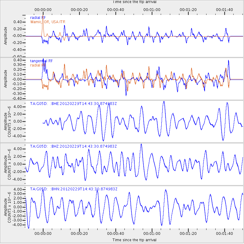
G05D Wamic, OR, USA - Earthquake Result Viewer
*The percent match for this event was below the threshold and hence no stack was calculated.
| Earthquake location: |
Near East Coast Of Honshu, Japan |
| Earthquake latitude/longitude: |
35.2/141.0 |
| Earthquake time(UTC): |
2012/02/29 (060) 14:32:47 GMT |
| Earthquake Depth: |
26 km |
| Earthquake Magnitude: |
5.6 MB, 5.5 MS, 5.6 MW, 5.7 MW |
| Earthquake Catalog/Contributor: |
WHDF/NEIC |
|
| Network: |
TA USArray Transportable Network (new EarthScope stations) |
| Station: |
G05D Wamic, OR, USA |
| Lat/Lon: |
45.24 N/121.32 W |
| Elevation: |
592 m |
|
| Distance: |
70.8 deg |
| Az: |
47.848 deg |
| Baz: |
300.752 deg |
| Ray Param: |
$rayparam |
*The percent match for this event was below the threshold and hence was not used in the summary stack. |
|
| Radial Match: |
62.88323 % |
| Radial Bump: |
381 |
| Transverse Match: |
46.47222 % |
| Transverse Bump: |
333 |
| SOD ConfigId: |
440406 |
| Insert Time: |
2012-05-15 06:10:57.004 +0000 |
| GWidth: |
2.5 |
| Max Bumps: |
400 |
| Tol: |
0.001 |
|
Signal To Noise
| Channel | StoN | STA | LTA |
| TA:G05D: :BHZ:20120229T14:43:30.874983Z | 1.6018752 | 1.9979184E-6 | 1.2472373E-6 |
| TA:G05D: :BHN:20120229T14:43:30.874983Z | 1.2181957 | 2.4930225E-6 | 2.046488E-6 |
| TA:G05D: :BHE:20120229T14:43:30.874983Z | 2.4214427 | 3.2184264E-6 | 1.3291359E-6 |
| Arrivals |
| Ps | |
| PpPs | |
| PsPs/PpSs | |


