You are here: Home > Network List > TA - USArray Transportable Network (new EarthScope stations) Stations List
> Station TPFO Pinon Flats, CA, USA > Earthquake Result Viewer
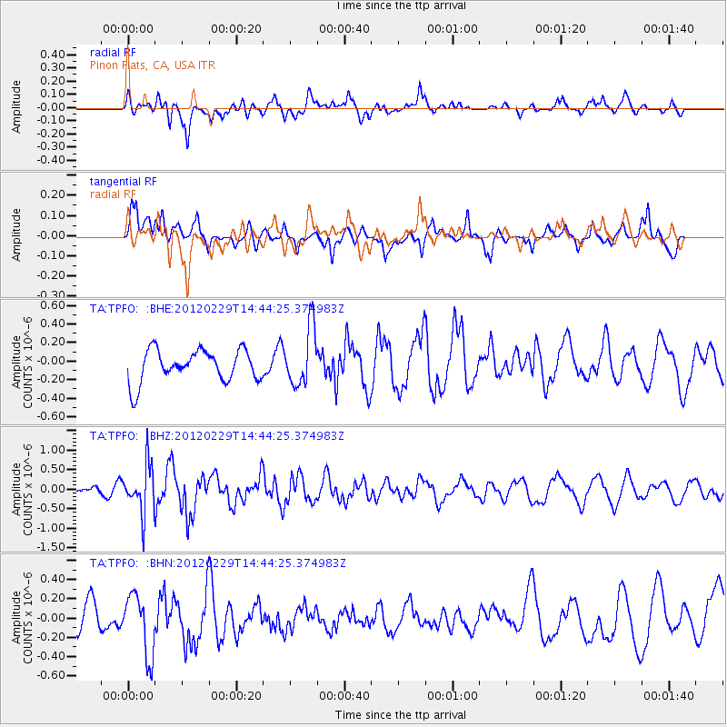
TPFO Pinon Flats, CA, USA - Earthquake Result Viewer
*The percent match for this event was below the threshold and hence no stack was calculated.
| Earthquake location: |
Near East Coast Of Honshu, Japan |
| Earthquake latitude/longitude: |
35.2/141.0 |
| Earthquake time(UTC): |
2012/02/29 (060) 14:32:47 GMT |
| Earthquake Depth: |
26 km |
| Earthquake Magnitude: |
5.6 MB, 5.5 MS, 5.6 MW, 5.7 MW |
| Earthquake Catalog/Contributor: |
WHDF/NEIC |
|
| Network: |
TA USArray Transportable Network (new EarthScope stations) |
| Station: |
TPFO Pinon Flats, CA, USA |
| Lat/Lon: |
33.61 N/116.45 W |
| Elevation: |
1275 m |
|
| Distance: |
80.3 deg |
| Az: |
55.725 deg |
| Baz: |
305.817 deg |
| Ray Param: |
$rayparam |
*The percent match for this event was below the threshold and hence was not used in the summary stack. |
|
| Radial Match: |
59.897175 % |
| Radial Bump: |
400 |
| Transverse Match: |
51.921253 % |
| Transverse Bump: |
383 |
| SOD ConfigId: |
440406 |
| Insert Time: |
2012-05-15 06:12:36.933 +0000 |
| GWidth: |
2.5 |
| Max Bumps: |
400 |
| Tol: |
0.001 |
|
Signal To Noise
| Channel | StoN | STA | LTA |
| TA:TPFO: :BHZ:20120229T14:44:25.374983Z | 1.6948408 | 6.174638E-7 | 3.6431965E-7 |
| TA:TPFO: :BHN:20120229T14:44:25.374983Z | 1.0742567 | 3.1872244E-7 | 2.9669113E-7 |
| TA:TPFO: :BHE:20120229T14:44:25.374983Z | 1.8545345 | 3.178489E-7 | 1.7139011E-7 |
| Arrivals |
| Ps | |
| PpPs | |
| PsPs/PpSs | |


