You are here: Home > Network List > G - GEOSCOPE Stations List
> Station INU Inuyama, Japan > Earthquake Result Viewer
INU Inuyama, Japan - Earthquake Result Viewer
| Earthquake location: |
Solomon Islands |
| Earthquake latitude/longitude: |
-5.8/154.3 |
| Earthquake time(UTC): |
1995/08/16 (228) 23:10:28 GMT |
| Earthquake Depth: |
74 km |
| Earthquake Magnitude: |
6.1 MB, 7.2 MS, 7.2 UNKNOWN, 7.2 MW |
| Earthquake Catalog/Contributor: |
WHDF/NEIC |
|
| Network: |
G GEOSCOPE |
| Station: |
INU Inuyama, Japan |
| Lat/Lon: |
35.35 N/137.03 E |
| Elevation: |
132 m |
|
| Distance: |
44.0 deg |
| Az: |
339.607 deg |
| Baz: |
154.905 deg |
| Ray Param: |
0.07195395 |
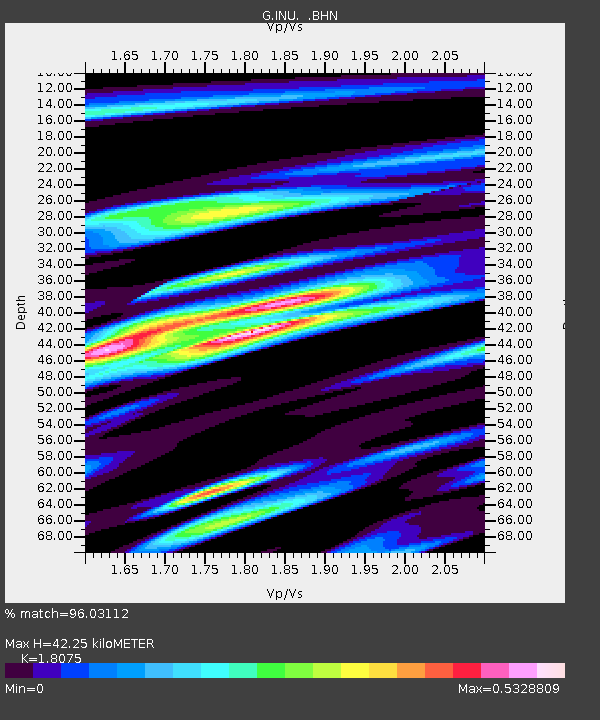
| Estimated Moho Depth: |
42.25 km |
| Estimated Crust Vp/Vs: |
1.81 |
| Assumed Crust Vp: |
6.461 km/s |
| Estimated Crust Vs: |
3.575 km/s |
| Estimated Crust Poisson's Ratio: |
0.28 |
|
| Radial Match: |
96.03112 % |
| Radial Bump: |
400 |
| Transverse Match: |
85.202934 % |
| Transverse Bump: |
400 |
| SOD ConfigId: |
6273 |
| Insert Time: |
2010-02-26 23:15:18.920 +0000 |
| GWidth: |
2.5 |
| Max Bumps: |
400 |
| Tol: |
0.001 |
|

Signal To Noise
| Channel | StoN | STA | LTA |
| G:INU: :BHN:19950816T23:17:58.600012Z | 5.815359 | 4.5822293E-7 | 7.8795296E-8 |
| G:INU: :BHE:19950816T23:17:58.600012Z | 3.7847083 | 2.3974465E-7 | 6.334561E-8 |
| G:INU: :BHZ:19950816T23:17:58.600012Z | 8.946552 | 8.6243125E-7 | 9.639817E-8 |
| Arrivals |
| Ps | 5.6 SECOND |
| PpPs | 17 SECOND |
| PsPs/PpSs | 23 SECOND |


