You are here: Home > Network List > CI - Caltech Regional Seismic Network Stations List
> Station SMM Simmler, CA, USA > Earthquake Result Viewer
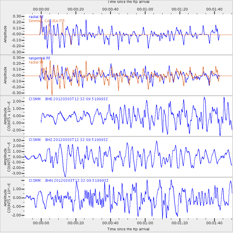
SMM Simmler, CA, USA - Earthquake Result Viewer
*The percent match for this event was below the threshold and hence no stack was calculated.
| Earthquake location: |
Southeast Of Loyalty Islands |
| Earthquake latitude/longitude: |
-22.1/170.3 |
| Earthquake time(UTC): |
2012/03/03 (063) 12:19:55 GMT |
| Earthquake Depth: |
14 km |
| Earthquake Magnitude: |
6.5 MB, 6.4 MS, 6.6 MW, 6.6 MW |
| Earthquake Catalog/Contributor: |
WHDF/NEIC |
|
| Network: |
CI Caltech Regional Seismic Network |
| Station: |
SMM Simmler, CA, USA |
| Lat/Lon: |
35.31 N/120.00 W |
| Elevation: |
599 m |
|
| Distance: |
87.3 deg |
| Az: |
50.15 deg |
| Baz: |
240.499 deg |
| Ray Param: |
$rayparam |
*The percent match for this event was below the threshold and hence was not used in the summary stack. |
|
| Radial Match: |
76.85027 % |
| Radial Bump: |
400 |
| Transverse Match: |
74.510826 % |
| Transverse Bump: |
400 |
| SOD ConfigId: |
440406 |
| Insert Time: |
2012-05-15 06:33:12.099 +0000 |
| GWidth: |
2.5 |
| Max Bumps: |
400 |
| Tol: |
0.001 |
|
Signal To Noise
| Channel | StoN | STA | LTA |
| CI:SMM: :BHZ:20120303T12:32:09.519993Z | 3.4230053 | 8.6478803E-7 | 2.5263998E-7 |
| CI:SMM: :BHN:20120303T12:32:09.519993Z | 2.3847954 | 6.4396784E-7 | 2.7003063E-7 |
| CI:SMM: :BHE:20120303T12:32:09.519993Z | 1.6103206 | 6.7687546E-7 | 4.2033585E-7 |
| Arrivals |
| Ps | |
| PpPs | |
| PsPs/PpSs | |


