You are here: Home > Network List > TA - USArray Transportable Network (new EarthScope stations) Stations List
> Station O02D Mt. Diablo Meridian, CA, USA > Earthquake Result Viewer
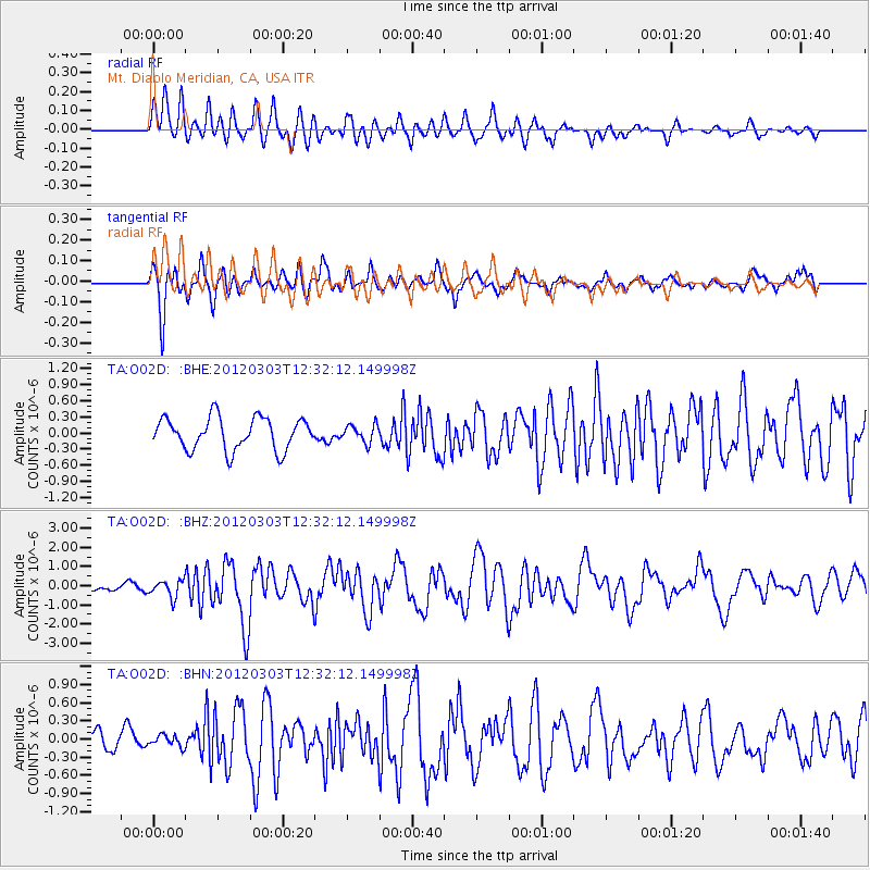
O02D Mt. Diablo Meridian, CA, USA - Earthquake Result Viewer
*The percent match for this event was below the threshold and hence no stack was calculated.
| Earthquake location: |
Southeast Of Loyalty Islands |
| Earthquake latitude/longitude: |
-22.1/170.3 |
| Earthquake time(UTC): |
2012/03/03 (063) 12:19:55 GMT |
| Earthquake Depth: |
14 km |
| Earthquake Magnitude: |
6.5 MB, 6.4 MS, 6.6 MW, 6.6 MW |
| Earthquake Catalog/Contributor: |
WHDF/NEIC |
|
| Network: |
TA USArray Transportable Network (new EarthScope stations) |
| Station: |
O02D Mt. Diablo Meridian, CA, USA |
| Lat/Lon: |
40.18 N/122.79 W |
| Elevation: |
965 m |
|
| Distance: |
87.8 deg |
| Az: |
44.84 deg |
| Baz: |
238.566 deg |
| Ray Param: |
$rayparam |
*The percent match for this event was below the threshold and hence was not used in the summary stack. |
|
| Radial Match: |
77.71498 % |
| Radial Bump: |
400 |
| Transverse Match: |
78.28807 % |
| Transverse Bump: |
400 |
| SOD ConfigId: |
440406 |
| Insert Time: |
2012-05-15 06:36:51.002 +0000 |
| GWidth: |
2.5 |
| Max Bumps: |
400 |
| Tol: |
0.001 |
|
Signal To Noise
| Channel | StoN | STA | LTA |
| TA:O02D: :BHZ:20120303T12:32:12.149998Z | 2.238066 | 4.3416037E-7 | 1.9398908E-7 |
| TA:O02D: :BHN:20120303T12:32:12.149998Z | 0.56613404 | 1.03571296E-7 | 1.8294483E-7 |
| TA:O02D: :BHE:20120303T12:32:12.149998Z | 0.5391241 | 1.6081474E-7 | 2.982889E-7 |
| Arrivals |
| Ps | |
| PpPs | |
| PsPs/PpSs | |


