You are here: Home > Network List > UW - Pacific Northwest Regional Seismic Network Stations List
> Station UMAT Pilot Rock, OR, USA > Earthquake Result Viewer
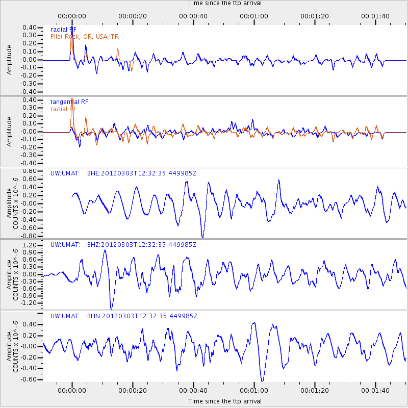
UMAT Pilot Rock, OR, USA - Earthquake Result Viewer
*The percent match for this event was below the threshold and hence no stack was calculated.
| Earthquake location: |
Southeast Of Loyalty Islands |
| Earthquake latitude/longitude: |
-22.1/170.3 |
| Earthquake time(UTC): |
2012/03/03 (063) 12:19:55 GMT |
| Earthquake Depth: |
14 km |
| Earthquake Magnitude: |
6.5 MB, 6.4 MS, 6.6 MW, 6.6 MW |
| Earthquake Catalog/Contributor: |
WHDF/NEIC |
|
| Network: |
UW Pacific Northwest Regional Seismic Network |
| Station: |
UMAT Pilot Rock, OR, USA |
| Lat/Lon: |
45.29 N/118.96 W |
| Elevation: |
1318 m |
|
| Distance: |
92.8 deg |
| Az: |
41.838 deg |
| Baz: |
241.175 deg |
| Ray Param: |
$rayparam |
*The percent match for this event was below the threshold and hence was not used in the summary stack. |
|
| Radial Match: |
58.140617 % |
| Radial Bump: |
300 |
| Transverse Match: |
65.15754 % |
| Transverse Bump: |
378 |
| SOD ConfigId: |
440406 |
| Insert Time: |
2012-05-15 06:38:00.590 +0000 |
| GWidth: |
2.5 |
| Max Bumps: |
400 |
| Tol: |
0.001 |
|
Signal To Noise
| Channel | StoN | STA | LTA |
| UW:UMAT: :BHZ:20120303T12:32:35.449985Z | 2.1858928 | 3.0542736E-7 | 1.397266E-7 |
| UW:UMAT: :BHN:20120303T12:32:35.449985Z | 1.7435774 | 1.2511029E-7 | 7.175494E-8 |
| UW:UMAT: :BHE:20120303T12:32:35.449985Z | 1.1574736 | 2.3026118E-7 | 1.9893429E-7 |
| Arrivals |
| Ps | |
| PpPs | |
| PsPs/PpSs | |


