You are here: Home > Network List > CI - Caltech Regional Seismic Network Stations List
> Station LRL Laurel Mtn Radio Fac, Ridgecrest, CA, USA > Earthquake Result Viewer
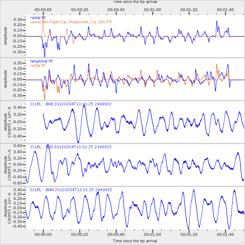
LRL Laurel Mtn Radio Fac, Ridgecrest, CA, USA - Earthquake Result Viewer
*The percent match for this event was below the threshold and hence no stack was calculated.
| Earthquake location: |
Southeast Of Loyalty Islands |
| Earthquake latitude/longitude: |
-21.5/169.8 |
| Earthquake time(UTC): |
2012/03/04 (064) 12:49:02 GMT |
| Earthquake Depth: |
14 km |
| Earthquake Magnitude: |
5.7 MW, 5.4 MS, 5.4 MB, 5.6 MW |
| Earthquake Catalog/Contributor: |
WHDF/NEIC |
|
| Network: |
CI Caltech Regional Seismic Network |
| Station: |
LRL Laurel Mtn Radio Fac, Ridgecrest, CA, USA |
| Lat/Lon: |
35.48 N/117.68 W |
| Elevation: |
1340 m |
|
| Distance: |
89.0 deg |
| Az: |
51.142 deg |
| Baz: |
242.666 deg |
| Ray Param: |
$rayparam |
*The percent match for this event was below the threshold and hence was not used in the summary stack. |
|
| Radial Match: |
62.888485 % |
| Radial Bump: |
394 |
| Transverse Match: |
62.18575 % |
| Transverse Bump: |
400 |
| SOD ConfigId: |
440406 |
| Insert Time: |
2012-05-19 23:34:55.414 +0000 |
| GWidth: |
2.5 |
| Max Bumps: |
400 |
| Tol: |
0.001 |
|
Signal To Noise
| Channel | StoN | STA | LTA |
| CI:LRL: :BHZ:20120304T13:01:25.244993Z | 1.8004416 | 4.299473E-7 | 2.3880102E-7 |
| CI:LRL: :BHN:20120304T13:01:25.244993Z | 1.3443115 | 1.7217282E-7 | 1.280751E-7 |
| CI:LRL: :BHE:20120304T13:01:25.244993Z | 0.9036559 | 2.0256859E-7 | 2.2416563E-7 |
| Arrivals |
| Ps | |
| PpPs | |
| PsPs/PpSs | |


