You are here: Home > Network List > TA - USArray Transportable Network (new EarthScope stations) Stations List
> Station 121A Cookes Peak, Deming, NM, USA > Earthquake Result Viewer
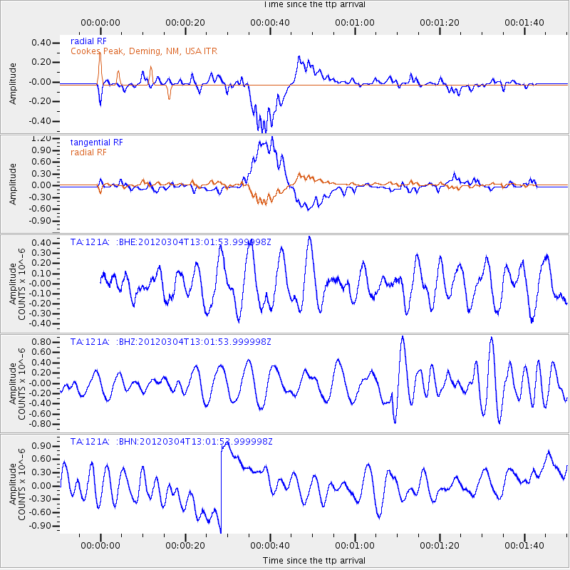
121A Cookes Peak, Deming, NM, USA - Earthquake Result Viewer
*The percent match for this event was below the threshold and hence no stack was calculated.
| Earthquake location: |
Southeast Of Loyalty Islands |
| Earthquake latitude/longitude: |
-21.5/169.8 |
| Earthquake time(UTC): |
2012/03/04 (064) 12:49:02 GMT |
| Earthquake Depth: |
14 km |
| Earthquake Magnitude: |
5.7 MW, 5.4 MS, 5.4 MB, 5.6 MW |
| Earthquake Catalog/Contributor: |
WHDF/NEIC |
|
| Network: |
TA USArray Transportable Network (new EarthScope stations) |
| Station: |
121A Cookes Peak, Deming, NM, USA |
| Lat/Lon: |
32.53 N/107.79 W |
| Elevation: |
1652 m |
|
| Distance: |
95.3 deg |
| Az: |
57.24 deg |
| Baz: |
247.958 deg |
| Ray Param: |
$rayparam |
*The percent match for this event was below the threshold and hence was not used in the summary stack. |
|
| Radial Match: |
55.062798 % |
| Radial Bump: |
400 |
| Transverse Match: |
66.87543 % |
| Transverse Bump: |
400 |
| SOD ConfigId: |
440406 |
| Insert Time: |
2012-05-19 23:37:24.598 +0000 |
| GWidth: |
2.5 |
| Max Bumps: |
400 |
| Tol: |
0.001 |
|
Signal To Noise
| Channel | StoN | STA | LTA |
| TA:121A: :BHZ:20120304T13:01:53.999998Z | 0.82489234 | 2.1219542E-7 | 2.5724015E-7 |
| TA:121A: :BHN:20120304T13:01:53.999998Z | 1.6698854 | 3.4233702E-7 | 2.050063E-7 |
| TA:121A: :BHE:20120304T13:01:53.999998Z | 1.9016521 | 2.0422983E-7 | 1.07396005E-7 |
| Arrivals |
| Ps | |
| PpPs | |
| PsPs/PpSs | |


