You are here: Home > Network List > CI - Caltech Regional Seismic Network Stations List
> Station SLA SLA, Trona, CA, USA > Earthquake Result Viewer
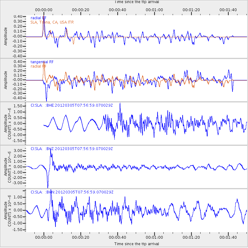
SLA SLA, Trona, CA, USA - Earthquake Result Viewer
*The percent match for this event was below the threshold and hence no stack was calculated.
| Earthquake location: |
Santiago Del Estero Prov., Arg. |
| Earthquake latitude/longitude: |
-28.2/-63.3 |
| Earthquake time(UTC): |
2012/03/05 (065) 07:46:10 GMT |
| Earthquake Depth: |
554 km |
| Earthquake Magnitude: |
6.0 MB, 6.1 MW, 6.1 MW |
| Earthquake Catalog/Contributor: |
WHDF/NEIC |
|
| Network: |
CI Caltech Regional Seismic Network |
| Station: |
SLA SLA, Trona, CA, USA |
| Lat/Lon: |
35.89 N/117.28 W |
| Elevation: |
1174 m |
|
| Distance: |
81.6 deg |
| Az: |
318.395 deg |
| Baz: |
133.828 deg |
| Ray Param: |
$rayparam |
*The percent match for this event was below the threshold and hence was not used in the summary stack. |
|
| Radial Match: |
56.254017 % |
| Radial Bump: |
400 |
| Transverse Match: |
72.27835 % |
| Transverse Bump: |
400 |
| SOD ConfigId: |
440406 |
| Insert Time: |
2012-05-19 23:45:52.277 +0000 |
| GWidth: |
2.5 |
| Max Bumps: |
400 |
| Tol: |
0.001 |
|
Signal To Noise
| Channel | StoN | STA | LTA |
| CI:SLA: :BHZ:20120305T07:56:59.070029Z | 9.371182 | 1.634972E-6 | 1.7446806E-7 |
| CI:SLA: :BHN:20120305T07:56:59.070029Z | 3.438977 | 6.223473E-7 | 1.8096871E-7 |
| CI:SLA: :BHE:20120305T07:56:59.070029Z | 1.0886583 | 4.17646E-7 | 3.8363365E-7 |
| Arrivals |
| Ps | |
| PpPs | |
| PsPs/PpSs | |


