You are here: Home > Network List > CI - Caltech Regional Seismic Network Stations List
> Station MPP McPhearson Peak > Earthquake Result Viewer
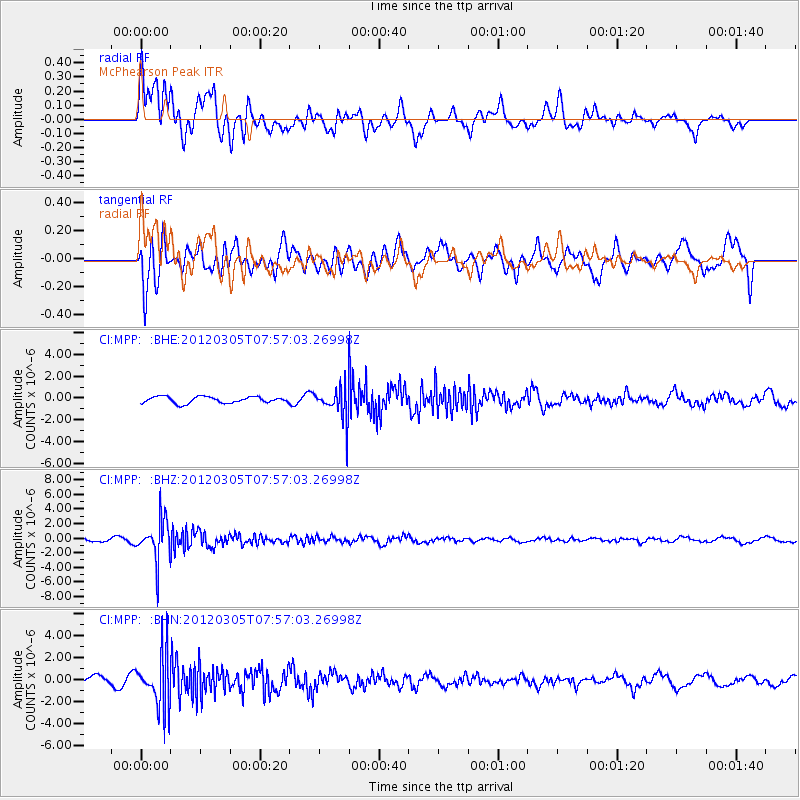
MPP McPhearson Peak - Earthquake Result Viewer
*The percent match for this event was below the threshold and hence no stack was calculated.
| Earthquake location: |
Santiago Del Estero Prov., Arg. |
| Earthquake latitude/longitude: |
-28.2/-63.3 |
| Earthquake time(UTC): |
2012/03/05 (065) 07:46:10 GMT |
| Earthquake Depth: |
554 km |
| Earthquake Magnitude: |
6.0 MB, 6.1 MW, 6.1 MW |
| Earthquake Catalog/Contributor: |
WHDF/NEIC |
|
| Network: |
CI Caltech Regional Seismic Network |
| Station: |
MPP McPhearson Peak |
| Lat/Lon: |
34.89 N/119.81 W |
| Elevation: |
1739 m |
|
| Distance: |
82.4 deg |
| Az: |
316.234 deg |
| Baz: |
132.068 deg |
| Ray Param: |
$rayparam |
*The percent match for this event was below the threshold and hence was not used in the summary stack. |
|
| Radial Match: |
59.97759 % |
| Radial Bump: |
400 |
| Transverse Match: |
65.399666 % |
| Transverse Bump: |
400 |
| SOD ConfigId: |
440406 |
| Insert Time: |
2012-05-19 23:46:34.588 +0000 |
| GWidth: |
2.5 |
| Max Bumps: |
400 |
| Tol: |
0.001 |
|
Signal To Noise
| Channel | StoN | STA | LTA |
| CI:MPP: :BHZ:20120305T07:57:03.26998Z | 9.170523 | 2.7716944E-6 | 3.0223953E-7 |
| CI:MPP: :BHN:20120305T07:57:03.26998Z | 8.425245 | 2.4131002E-6 | 2.8641307E-7 |
| CI:MPP: :BHE:20120305T07:57:03.26998Z | 4.9103217 | 1.4590798E-6 | 2.9714545E-7 |
| Arrivals |
| Ps | |
| PpPs | |
| PsPs/PpSs | |


