You are here: Home > Network List > IW - Intermountain West Stations List
> Station PLID Pearl Lake, Idaho, USA > Earthquake Result Viewer
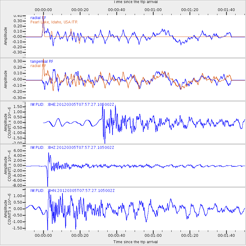
PLID Pearl Lake, Idaho, USA - Earthquake Result Viewer
*The percent match for this event was below the threshold and hence no stack was calculated.
| Earthquake location: |
Santiago Del Estero Prov., Arg. |
| Earthquake latitude/longitude: |
-28.2/-63.3 |
| Earthquake time(UTC): |
2012/03/05 (065) 07:46:10 GMT |
| Earthquake Depth: |
554 km |
| Earthquake Magnitude: |
6.0 MB, 6.1 MW, 6.1 MW |
| Earthquake Catalog/Contributor: |
WHDF/NEIC |
|
| Network: |
IW Intermountain West |
| Station: |
PLID Pearl Lake, Idaho, USA |
| Lat/Lon: |
45.09 N/116.00 W |
| Elevation: |
2164 m |
|
| Distance: |
87.3 deg |
| Az: |
325.656 deg |
| Baz: |
135.363 deg |
| Ray Param: |
$rayparam |
*The percent match for this event was below the threshold and hence was not used in the summary stack. |
|
| Radial Match: |
56.750755 % |
| Radial Bump: |
400 |
| Transverse Match: |
55.15226 % |
| Transverse Bump: |
400 |
| SOD ConfigId: |
440406 |
| Insert Time: |
2012-05-19 23:50:10.856 +0000 |
| GWidth: |
2.5 |
| Max Bumps: |
400 |
| Tol: |
0.001 |
|
Signal To Noise
| Channel | StoN | STA | LTA |
| IW:PLID: :BHZ:20120305T07:57:27.105002Z | 24.534773 | 2.5859606E-6 | 1.0539981E-7 |
| IW:PLID: :BHN:20120305T07:57:27.105002Z | 3.3898437 | 6.7034523E-7 | 1.9775106E-7 |
| IW:PLID: :BHE:20120305T07:57:27.105002Z | 4.176674 | 7.600328E-7 | 1.8197082E-7 |
| Arrivals |
| Ps | |
| PpPs | |
| PsPs/PpSs | |


