You are here: Home > Network List > TA - USArray Transportable Network (new EarthScope stations) Stations List
> Station 435B Jarrell, TX, USA > Earthquake Result Viewer
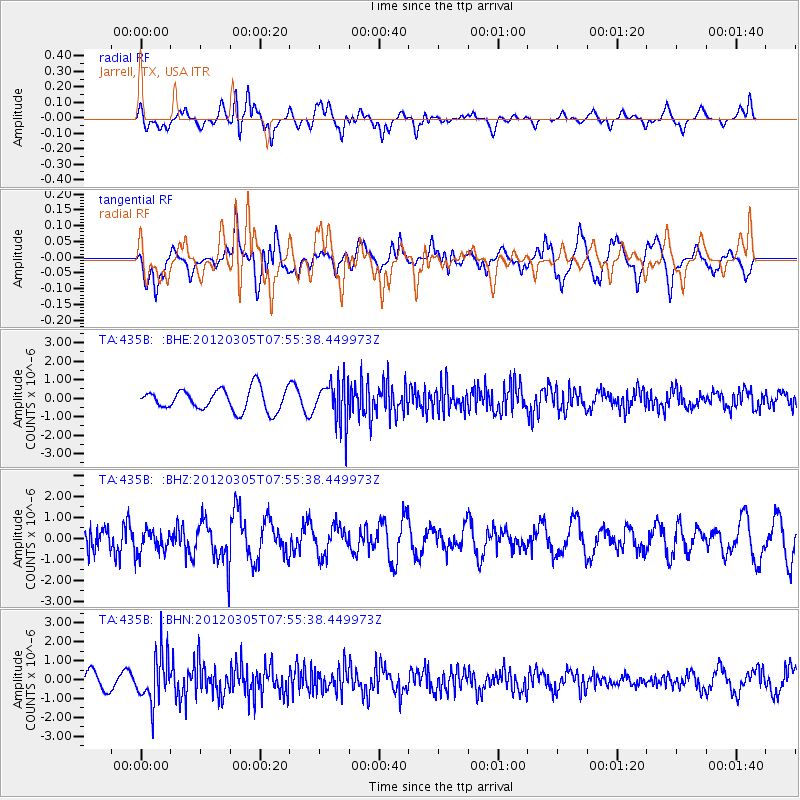
435B Jarrell, TX, USA - Earthquake Result Viewer
*The percent match for this event was below the threshold and hence no stack was calculated.
| Earthquake location: |
Santiago Del Estero Prov., Arg. |
| Earthquake latitude/longitude: |
-28.2/-63.3 |
| Earthquake time(UTC): |
2012/03/05 (065) 07:46:10 GMT |
| Earthquake Depth: |
554 km |
| Earthquake Magnitude: |
6.0 MB, 6.1 MW, 6.1 MW |
| Earthquake Catalog/Contributor: |
WHDF/NEIC |
|
| Network: |
TA USArray Transportable Network (new EarthScope stations) |
| Station: |
435B Jarrell, TX, USA |
| Lat/Lon: |
30.78 N/97.58 W |
| Elevation: |
248 m |
|
| Distance: |
67.2 deg |
| Az: |
328.266 deg |
| Baz: |
147.371 deg |
| Ray Param: |
$rayparam |
*The percent match for this event was below the threshold and hence was not used in the summary stack. |
|
| Radial Match: |
48.757137 % |
| Radial Bump: |
400 |
| Transverse Match: |
65.178276 % |
| Transverse Bump: |
400 |
| SOD ConfigId: |
440406 |
| Insert Time: |
2012-05-19 23:56:51.565 +0000 |
| GWidth: |
2.5 |
| Max Bumps: |
400 |
| Tol: |
0.001 |
|
Signal To Noise
| Channel | StoN | STA | LTA |
| TA:435B: :BHZ:20120305T07:55:38.449973Z | 0.36014792 | 5.556016E-7 | 1.5427039E-6 |
| TA:435B: :BHN:20120305T07:55:38.449973Z | 4.2642956 | 1.2764411E-6 | 2.993322E-7 |
| TA:435B: :BHE:20120305T07:55:38.449973Z | 1.9368935 | 1.1315726E-6 | 5.8422034E-7 |
| Arrivals |
| Ps | |
| PpPs | |
| PsPs/PpSs | |


